Pages

Sending Uranium through Barrier Reef is not a Problem

The Queensland government says it would consider shipping uranium through the Great Barrier Reef if a new advisory committee made the recommendation. The comments come as the United Nation's environmental arm considers whether to list the reef as a World Heritage site in danger. In a report earlier this year, UNESCO identified shipping as one of the most pressing threats to the reef's future.

Want to read UNESCO Daily News Updates? Click

Shipping over Great Barrier Reef ports

Shipping over Great Barrier Reef portsThe Queensland government this month lifted a long-standing ban on the mining of uranium in Queensland, despite saying before and after the March election it had no plans to do so. Chairman of the government's new uranium mining implementation committee, and Central Highlands councillor Paul Bell, revealed on Wednesday that all options are being examined, including shipping the ore from Great Barrier Reef ports.

The committee will also look at whether uranium could be transported on the Adelaide to Darwin rail line, for export through either of those cities. Natural Resources and Mines Minister Andrew Cripps says the whole point of establishing the committee is to get the best possible advice about how the uranium industry can recommence in Queensland.

"If the committee comes back and recommends that we identify locations for the transport of uranium products out of Queensland, obviously I'd be very positive about that," he told reporters.

Blue Hole Barrier Reef Australia
Blue Hole

"We need to identify the facilities and the locations where that could be done safely, as far as environmental standards and workplace health and safety standards are concerned, and that's the whole purpose of appointing this implementation committee."

Mr Cripps said the committee's advice will help guide the recommencement of the industry in an orderly fashion and in a safe way for all Queenslanders.

Mr Cripps said it was unfortunate that Queensland Conservation (QC) had turned down an invitation to join the committee.

QC director Toby Hutcheon said being a committee member wouldn't allow his group to challenge the decision to restart uranium mining as it was "an implementation committee, not a feasibility committee"

"We were invited and we declined," he said. "We don't believe there is a case for it in Queensland, the reality is the government should have done a feasibility study to find out the economic, social and environmental implications before making the decision."

Mr Hutcheon said the economic factors didn't stack up and QC didn't believe uranium mining would actually go ahead in Queensland. "The government is talking up the economic opportunities, when at the same time you've got the world's biggest uranium deposit at Olympic Dam being mothballed because there's no demand," he said.

"Western Australia allowed uranium mining in 2008 and not a single mine has been built." However Mr Hutcheon was still worried about the potential impacts of any uranium exports through the Great Barrier Reef.

"If a ship a run aground on the reef not only does it do damage physically, but if it's containing radioactive material like uranium ore that adds massively to the threat faced by the reef," he said.

In a June report, UNESCO was highly critical of Australia's management of the Great Barrier Reef.

It said coastal development, ports and shipping were among the most pressing threats, and there was no overall plan for the future sustainable development of the reef. The Queensland and federal governments are currently compiling a strategic assessment of the entire reef area in response to UNESCO's concerns. The report is due to be presented to the UN body early next year.

Browse All UNESCO World Heritage Sites in . The original Source File!!!

#915 Whale sharks off Cancun, Mexico

During the summer months, if you travel about an hour's speedboat ride off the coast of Cancun and Isla Mujeres in Mexico, you will come to a place where there are often hundreds of whale sharks swimming. The krill and plankton sits on the surface, and therefore, so do the whale sharks. In an industry highly regulated by the Mexican government, you are permitted to swim with them. Wow! What an amazing experience! They are so large and peaceful, with their wide mouths and swishing tails. They say if you can take a picture of their finger-print side, this unique genetic code can be posted online to tell you where else in the world they have been to.
Isla Mujeres for lunch!

Civil War in Syria Done Irreparable Damage

The civil war in Syria war threatens to do irreparable damage to the country's archaeological treasures. When UNESCO described the Great Mosque of Aleppo as "one of the most beautiful mosques in the Muslim world", few would have begged to differ. The landmark12th-century building was an icon of Islamic architecture. As well as a place of worship, it served as a document of history, a national treasure and a testament to the breath-taking beauty that architecture can inspire.

Want to read UNESCO Daily News Updates? Click

The Fate of Ummayad Mosque

Ummayad Mosque after warUntil two weeks ago, that is, when it was ravaged by fire. Now, the famous stonewash courtyard is charred by flames. The domed interiors, hung with gold chandeliers, lie in rubble. Enamelled mosaic tiles are scattered on the floor alongside broken windows and empty ammunition cases. The fate of the Ummayad mosque is becoming a sadly familiar story for the cultural heritage of Syria. Earlier this month, the centuries-old Aleppo souk was destroyed, adding to an ever-increasing list of archaeological devastation.

There are six UNESCO world heritage sites in Syria – sites so important to human history that they have an international mandate to protect them; not one of them has so far escaped the conflict unscathed.

The destruction to historic sites is one of the less-reported on results of the civil war in Syria, and understandably so – next to the devastating human cost, it seems almost callous to worry about the fate of inanimate objects. Yet as Irina Bokova, director general of UNESCO noted, "The historic and highly symbolic value of this heritage … [needs to be preserved] for the whole of humanity."

It is difficult to overstate Syria's archaeological significance – the landscape is nothing short of a palimpsest of world history. Throughout the country, the remains and ruins of building chart the rise and fall of centuries over the millennia. From Neolithic fragments to Bronze age friezes, Roman temples, Mesopotamian trade routes, early Christian churches and some of the most magnificent Islamic art ever created, Syria can rightly be regarded as a living museum. But now, these pages of history are now in serious danger of being wiped for ever.

Syria is a signatory to the 1954 Hague Convention for the Protection of Cultural Property in the Event of Armed Conflict, meaning that there is an international incentive to intervene to protect its cultural heritage. Whilst many NGOs and archeological organisations are campaigning for this, the scale of the conflict has largely restricted their actions so far to mere lobbying.

UNESCO has released several statements calling for appeals, with the hope of being able to send someone in to assess the damage if the situation permits. Smaller groups are doing their best to publicise their damage as well, and the Syrian-based Directorate-General of Antiquities and Museums (DGAM) are actively working on monitoring the situation. Yet, when dealing with a crisis of this magnitude – when the safety and protection of civilians cannot even be secured – people are increasingly asking what hope there can be for architecture?

As Julien Anfruns, the Director General of ICOM (the International Council of Museums) notes, "When we deal with these emergencies, our first action is to evaluate [the damage] …when we are in places in which it is very difficult to intervene because of combats, satellite monitoring is really instrumental."

Indeed, satellite monitoring of certain cultural sites has been deployed in some areas of Syria already, but the high financial cost and relatively low priority of this means that it offers a far from conclusive picture of the damage.

In response to this, alternate, practical ways to chart the destruction are developing. Syrians, concerned about their heritage, are increasingly using ground-level footage taken on mobile phones and video-cameras to survey the most important sites. One of the most extensive is the Facebook page "Le patrimoine archéologique syrien en danger". Founded by several Syrian and European archaeologists, the group is endeavoring to compile as accurate a picture as possible of damage to historic sites through posted photographs and eye-witness reports. It is proving to be an invaluable resource.

Lawrence Rothfield, former director of the Cultural Policy Center at the University of Chicago, believes that new technologies offer some of the most effective ways to tackle the crisis. "What we need at the moment is real-time or close-to-real-time evidence, which cell phone technology can provide at a much lower cost [than satellites]".

"If the warring parties know that they can be indicted for war crimes based on imagery showing they were the first to move onto a protected site or that they are enabling and profiting from the looting of sites, they may think twice".

Damage from shelling and gunfire is only one of the hazards affecting Syria's cultural heritage. The almost incalculable international value of such scholarly objects means that looting is a huge danger. As Emma Cunliffe, a doctoral student in archaeology at Durham University, who has compiled one of the most definitive reports on the damage in Syria so far, observes: "Looting is going to be a huge problem.

There are a lot of videos online of looting at the world heritage, and that's very worrying because they're the prominent ones, and I've heard circulating reports of damage at smaller sites as well". Previous experience with looting, notably in post-conflict Iraq suggests that future prospects are bleak. "In Iraq, these looter gangs were getting up to 200 people, and the problem is you can put resources in place at one site – even if you did have the resources to scare off two hundred guys – they would just go to the next one. And you can't have two hundred people at every site".

Like the Ummayad mosque, many of the most important Syrian sites are built in militarily strategic locations (the crusaders had reasons for their geographic specifications), and these are most likely to be appropriated by one or both of the warring parties in the current conflict. Even with international awareness increasing, one thing is guaranteed: as long as the conflict continues, damage to cultural sites will continue.

Browse All UNESCO World Heritage Sites in . The original Source File!!!

The Archaeological Survey of India Needs 3 More Heritage Sites

The Archaeological Survey of India (ASI) has recommended 3 more heritage sites to the UNESCO to accord World Heritage status to Hire Benakal, Bijapur-Bidar and the Pattadkal-Aihole-Badami-Mahakoota cluster. Announcing this on the third anniversary of the Indo-Asian Foundation of Archaeological Research (IAFAR) on Monday, D. Dayalan, Regional Director ASI, said there was also a plan to recommend Hoysala sites in Belur, Halebid and Somanathapura for World Heritage status.

Want to read UNESCO Daily News Updates? Click

Recommending 3 Sites

Benakal Pre-historic TombsHire Benakal is a small village in Gangavathi taluk of Koppal district — is the location of an "enormous" and "isolated" megalithic site. Bijapur and Bidar have some stunning architectural examples of Bahmani architecture. Pattadkal is already a world heritage site, and the ASI has recommended that the Aihole, Badami and the Mahakoota group of temples of Bagalkot district become part of it. Hire Benakal monuments were built more than 1,000 years ago spanning the southern Indian Iron Age and Early Historic periods, he said.

There are more than 1,000 mausoleums-like tombs spread over 50 acres of land. Tombs were constructed from upright slabs topped by cap stones. "It is a little-known Iron Age cemetery," he said. The finding of Emperor Ashoka's inscription during excavation at Sannithi near Gulbarga had opened another chapter in the archaeological history of India. "At the foot of the statue, Ashoka's name was found inscribed as 'Raya Ashoka' in Brahmi script in Prakrut," he said. The ASI had located a Buddhist stupa and mud fort while undertaking excavations at Sannithi, besides edicts, and inscriptions belonging to different periods, he added.

Noting that there were seven site museums under the control of the ASI, besides some that come under the State Archaeology Department, he said there was a plan to make Kanagananhalli, an important Buddhist site, as a site museum, he disclosed.

Benakal Pre-historic Tombs in India
Benakal Pre-historic Tombs

Later, speaking to presspersons on the sidelines of the programme, Dr. Dayalan said that the process of recruiting staff for the department had commenced and there was a likelihood of recruiting 200 staff in the next six months.

Browse All UNESCO World Heritage Sites in .

Sun Temple Konarak Orissa

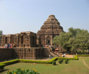
Sun Temple, Konarak is located on the shores of the Bay of Bengal, bathed in the rays of the rising sun, the temple at Konarak is a monumental representation of the sun god Surya's chariot; its 24 wheels are decorated with symbolic designs and it is led by a team of six horses. Built in the 13th century, it is one of India's most famous Brahman sanctuaries. Konarak is an outstanding testimony to the 13th-century kingdom of Orissa. It is directly and materially linked to Brahmin beliefs, and forms the invaluable link in the history of the diffusion of the cult of Surya, which originated in Kashmir during the 8th century and finally reached the shores of eastern India.

Sun Temple Konarak Orissa India
Continent: Asia
Country: India
Category: Cultural
Criterion: (I)(III) (VI)
Date of Inscription: 1984

Brahmin temple of Kimarak

On the eastern coast of India, south of the Mahanadi Delta, is the Brahmin temple of Kimarak (still spelled as Konarak or Konarka), one of the most famous Brahmin sanctuaries of Asia. Konarak derives its name from Konarka, the presiding deity of the Sun Temple. Konarka is a combination of two words, kona (corner) and arka (Sun). It was one of the earliest centres of Sun worship in India. Built around 1250 in the reign of King Narasingha Deva (1238-64), it marks the apogee of the wave of foundations dedicated to the Sun God Surya; the entire temple was conceived as a chariot of the Sun God with a set of spokes and elaborates carvings.

The present Sun Temple was probably built by King Narashimhadev I (1238-64) of the Ganga dynasty to celebrate his victory over the Muslims. The temple fell into disuse in the early 17th century after it was desecrated by an envoy of the Mughal Emperor Jahangir. The legend has it that the temple was constructed by Samba, the son of Lord Krishna. Samba was afflicted by leprosy and after twelve years of penance he was cured by Surya, the Sun God, in whose honour he built this temple.

Sun Temple Konarak Orissa
Sun Temple Konarak

Browse Gallery Plus UNESCO Storyline

Against the horizon, on the sandy shore, where the rising Sun emerges from the waters of the Gulf of Bengal, stands the temple, built from stone and carefully oriented so as to permit the first rays of the Sun to strike its principal entry. It is a monumental representation of the chariot of Surya pulled by a team of seven horses (six of which still exist and are placed on either side of the stairway leading to the sanctuary).

Slideshow for this Heritage Site


On the north and south sides, 24 wheels some 3 m in diameter, lavishly sculptured with symbolic motives referring to the cycle of the seasons and the months, complete the illusionary structure of the temple-chariot. Between the wheels, the plinth of the temple is entirely decorated with reliefs (fantastic lions, musicians and dancers, erotic groups). Like many Indian temples, Konarak comprises several distinct and well-organized spatial units.

The vimana (principal sanctuary) was surmounted by a high tower with a sikkara which was razed in the 19th century; to the east, the jahamogana (audience hall) now dominates the ruins with its pyramidal mass, the original effect.

Further to the east, the natmandir (dance hall), today unroofed, rises on a high platform. Various subsidiary structures are still to be found within the enclosed area of the rectangular wall, which is punctuated by its gates and towers.

Apart from the Puranas, other religious texts also point towards the existence of a Sun temple at Konarak long before the present temple. Konarak was once a bustling port of Kalinga and had good maritime trade relations with South-East Asian countries.

Browse All UNESCO World Heritage Sites in . The original UNESCO inscription Here!!!

The Rock Shelters and Paintings of Bhimbetka

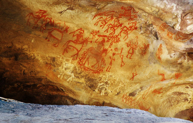
The Rock Shelters and Paintings of Bhimbetka are in the foothills of the Vindhyan Mountains on the southern edge of the central Indian plateau. Within massive sandstone outcrops, above comparatively dense forest, are five clusters of natural rock shelters, displaying paintings that appear to date from the Mesolithic Period right through to the historical period. The cultural traditions of the inhabitants of the twenty-one villages adjacent to the site bear a strong resemblance to those represented in the rock paintings.

The Rock Shelters and Paintings of Bhimbetka
Continent: Asia
Country: India
Category: Cultural
Criterion: (III)(V)
Date of Inscription: 2003

Bhimbetka Buddhist site

Bhimbetka reflects a long interaction between people and the landscape. It is closely associated with a hunting and gathering economy, as demonstrated in the rock art and in the relicts of this tradition in the local adivasi villages on the periphery of the site. The site complex was discovered by V. S. Wakankar in 1957. Almost 100 years earlier, in 1867, rock paintings had been discovered in Uttar Pradesh and the first scientific article on Indian rock paintings was published by J. Cockburn in 1883. Bhimbetka was first mentioned in 1888 as a Buddhist site, from information obtained from local adivasis. Two shelters were excavated in 1971 by Bajpai, Pandey and Gour.

The following year a systematic survey of the wider area from Kari Talai to Jaora was undertaken by Wakankar. His classification into seven topographical areas (I-VII), within which clusters of shelters were numbered alphabetically, and individual shelters given Arabic numeral, is still followed. This survey identified 700 shelters of which 243 are in the Bhimbetka group. It also showed the Lakha Juar Group to be is as rich as Bhimbetka in rock paintings, with 178 shelters spread over two hills.

The Rock Shelters and Paintings of Bhimbetka India
The Rock Shelters of Bhimbetka

Browse Gallery Plus UNESCO Storyline

So far excavations have been limited to Bhimbetka. Between 1972 and 1977 excavation undertaken by Wakanakar, Misra and Hass revealed a continuous sequence of Stone Age cultures from the late Acheulian to the late Mesolithic and also some of the world's oldest stone walls and floors. Wakanakar revealed stratified deposits including Chalcolithic pottery, which indicated contact with Chalcolithic man on the neighbouring plains. The excavated material has been examined to establish sequence and typology for stone tools.

Slideshow for this Heritage Site


So far there is no conclusive corroboration between the excavated material and the wall paintings - for which absolute dates have not been established. Nevertheless circumstantial evidence from pigments in deposits and images that indicate pre-agricultural societies, together with similarities with pottery patterns of the Chalcolithic Malwa ware, indicates that the earliest paintings are from the Mesolithic period.

A broad chronology has been established but more work is needed to establish a detailed chronology. Similarly the nature of the societies associated with the paintings is as yet little known. And as has been mentioned earlier, no ethnographic work has been carried out on the surrounding villages to research links with the culture of the rock shelter sites.

The nominated Bhimbetka rock shelters site lies within the Vindhyan Hills, an area of massively sculpted sandstone rock formations clustered around Bhimbetka Hill. The area has abundant natural resources - perennial water supplies, natural shelter, rich forest flora and fauna, and these conditions of plenty seem to have been conducive to the development of sustainable and persistent societies and the creation of notable rock art.

The site includes five clusters of rock shelters, with one large complex in the buffer zone. The rock shelters display persistent traditions of rock painting, spanning periods from the Mesolithic to the Historic. They also display a profusion, richness and variety of mural subjects and, as a collection, form one of the densest known concentrations of rock art.

Many of the rock shelters within the area are set within fairly dense forest, which displays a high diversity of flora and fauna, still harvested by the local people. Overall the landscape has a strong appealing aesthetic quality, derived from the beauty of the naturally sculpted rock formations and the contrasting lush, densely wooded vegetation, which together give the place a 'timeless' quality.

Browse All UNESCO World Heritage Sites in . The original UNESCO inscription Here!!!

Sandstone Tower of Qutb Minar and its Monuments

Qutb Minar was built in the early 13th century a few kilometres south of Delhi; the red sandstone tower of Qutb Minar is 72.5 m high, tapering from 2.75 m in diameter at its peak to 14.32 m at its base, and alternating angular and rounded flutings. The surrounding archaeological area contains funerary buildings, notably the magnificent Alai-Darwaza Gate, the masterpiece of Indo-Muslim art (built in 1311), and two mosques, including the Quwwatu'l-Islam, the oldest in northern India, built of materials reused from some 20 Brahman temples.

Sandstone Tower of Qutb Minar and its Monuments
Continent: Asia
Country: India
Category: Cultural
Criterion: (IV)
Date of Inscription: 1993

The Qutb Complex

Lalkot is the first of the seven cities of Delhi, established by the Tomar Rajput ruler, Anang Pal, in 1060. The Qutb complex lies in the middle of the eastern part of Lalkot. Building of the Quwwatu'l-Islam (Might of Islam) congregational mosque was begun in 1192 by Qutbu'd-Din Aibak and completed in 1198, using the demolished remains of Hindu temples. It was enlarged by Iltutmish (1211-36) and again by Alauld-Din Khalji (1296-1316).

The Qutb Minar was also begun by Qutbu'd-Din Aibak, in around 1202 and completed by his successor, Muhammad-bin-Sam. It was damaged by lightning in 1326 and again in 1368, and was repaired by the rulers of the day, Muhammad-bin-Tughluq (1325-51) and Firuz Shah Tughluq (1351-88). In 1503 Sikandar Lodi carried out some restoration and enlargement of the upper storeys. The iron pillar in the mosque compound was brought from elsewhere in India.

Sandstone Tower of Qutb Minar and its Monuments Delhi India
Qutb Minar

Browse Gallery Plus UNESCO Storyline

It bears a Sanskrit inscription from the 4th century AD describing the exploits of a ruler named Chandra, believed to be the Gupta King Chandragupta II (375-413). Of the other monuments, the Tomb of Iltutmish was built in 1235 by the ruler himself and Alai Darwaja was built in 1311 by Alauld-Din Khalji, who also began the construction of the Alai Minar.

Slideshow for this Heritage Site


The Quwwatu'l-Islam mosque consists of a courtyard, cloisters, and a prayer hall. The high arched screen facing the prayer hall was added in the 14th century. The Qutb Minar is a column built from red and buff sandstone blocks rising to a height of 72.5 m, tapering from 2.75 m diameter at the top to 14.32 m at the base, making it the highest stone tower in India.

In addition to its traditional use for calling the faithful to prayer, it also has a monumental purpose, since a later Nagari inscription calls it Alauld-Din's 'victory monument' (Vijava-stambha). In its present form it consists of five storeys, the topmost of the original four storeys having been replaced by two storeys during the reign of Firuz Shah Tughluq. Each storey is separated from the next by highly decorated balconies, with pendentives and inscribed bands. The three earlier storeys are each decorated differently, the lowest being of alternating angular and rounded flutings, the second with rounded flutings alone, and the third with angular flutings alone; the same vertical alignment continues, however, through all three storeys.

The whole structure was originally surmounted by a cupola, which fell during an earthquake and was replaced by a new cupola in late Mughal style in the early 19th century. This was so incongruous that it was removed in 1848 and now stands on the lawns to the south-east of the minaret.

The Iron Pillar is 7.02 m long, 0.93 m of which is below ground. It is built up of many hundreds of small wrought-iron blooms welded together and is the largest known composite iron object from so early a period. The remarkable lack of corrosion is attributable to the combination of several factors, among them the high corrosion-resistance of wrought iron, the climatic conditions in Delhi, and the likelihood that it was frequently anointed with ghee (melted butter).

The deep cavity at the top suggests that it may at one time have been crowned by a Garuda image. The ornate Tomb of Iltutmish is in the north-west corner of the mosque. It consists of a square chamber of red sandstone with the tomb itself in the centre on a raised platform. The lower part of the interior is covered with fine Islamic carvings and arabesques. There is a marble mihrab (prayer niche) in the centre of the interior west wall.

The Alai Darwaza, built from red sandstone and elaborately carved, is the southern entrance to the enlarged enclosure of the Qutb complex. The Alai Minar, to the north of the enclosure, is the base of a second minaret which was to overtop the Qutb Minar. It was begun by Alau'd-Din-Khalji, but he died before it reached the first storey and work on the structure was abandoned.

Browse All UNESCO World Heritage Sites in . The original UNESCO inscription Here!!!

The Beauty of Mountain Railways in India

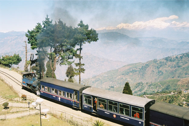
The Beauty of Mountain Railways in India heritage property includes three railways. The Darjeeling Himalayan Railway was the first, and is still the most outstanding, example of a hill passenger railway. Opened in 1881, its design applies bold and ingenious engineering solutions to the problem of establishing an effective rail link across a mountainous terrain of great beauty. The construction of the Nilgiri Mountain Railway, a 46-km long metre-gauge single-track railway in Tamil Nadu State was first proposed in 1854, but due to the difficulty of the mountainous location the work only started in 1891 and was completed in 1908. This railway, scaling an elevation of 326 m to 2,203 m, represented the latest technology of the time. The Kalka Shimla Railway, a 96-km long, single track working rail link built in the mid-19th century to provide a service to the highland town of Shimla is emblematic of the technical and material efforts to disenclave mountain populations through the railway. All three railways are still fully operational.

The Beauty of Mountain Railways in India
Continent: Asia
Country: India
Category: Cultural
Criterion: (II)(IV)
Date of Inscription: 1999

The development of railways in the 19th Century

The development of railways in the 19th century had a profound influence on social and economic developments in many parts of the world. The two Mountain Railways of India on the World Heritage List are outstanding examples of the interchange of values on developments in technology, and the impact of innovative transportation system on the social and economic development of a multicultural region, which was to serve as a model for similar developments in many parts of the world.

The Darjeeling Himalayan Railway is intimately linked with the development of Darjeeling as the queen of hill stations and one of the main tea-growing areas in India, in the early 19th century. The densely wooded mountain spur on which Darjeeling now stands was formerly part of the Kingdom of Sikkim. It was adopted by the British East India Company as a rest and recovery station for its soldiers in 1835, when the area was leased from Sikkim and building of the hill station began, linked to the plains by road.

The development of mountain railways in the 19th Century
Mountain Railways India

Browse Gallery Plus UNESCO Storyline

In 1878 the Eastern Bengal Railway submitted a detailed proposal for a steam railway from Siliguri, already linked with Calcutta to Darjeeling. This received official approval and construction work began immediately, and by 1881 it had been completed. Since 1958 it has been managed by the State-owned Northeast Frontier Railway.

The DHR consists of 88.48 km of 2 ft (0.610 m) gauge track that connects New Jalpaiguri with Darjeeling, passing through eleven stations between the two termini. One of these, Ghoom, is the second highest railway station in the world, at an altitude of 2258m. Because it passes through a mountainous region, 73% of the total length of the line consists of curves, the sharpest of which is that between Sukna and Rongtong, where the track passes through 120°.

Slideshow for this Heritage Site


There are six reverses and three loops on the line, the most famous of these being the Batasia Loop between Ghoom and Darjeeling. The steepest gradient is 1 in 18 (in zigzag reverses). The Toy Train, as it is affectionately known, affords breathtaking views of high waterfalls, green valleys that are often hidden by cloud, and at its end the splendid panorama of the snow-capped Kanchenjunga range.

There are several distinct sections: the 10 km plains section between Siliguri and Sukna (partly urban and partly agricultural), the 11 km densely forested section from Sukna to beyond Rongtong, the 38 km largely deforested open hill section with its many tea gardens to Kurseong, and finally the 30 km alpine section to Darjeeling, dominated by stands of Himalayan pine and tea gardens.

The Nilgiri Mountain Railway consists of 45.88 km of a 1 m gauge single-track, partly rack-and-pinion railway that connects Mettupalayiyam to Udagamandalam in Tamil Nadu State. The railway can be divided into three sections:

Some 7 km, from Mettupalaiyam to Kallar (elevation 405 m), across the central plain of Tamil Nadu, with its betel-nut palm and other plantations. Maximum speed is 30 km/h called the Blue Mountain Express, the name of which was changed recently to the native Nilgiri Express.

The rack section of the line, from Kallar to Coonoor (elevation 1,712 m). There are 208 curves and 13 tunnels, and 27 viaducts. The Kallar Bridge over the River Bhawani, the Adderley Viaduct and the Burliar Bridge are examples of such composite bridges. Here, the railway climbs through almost uninhabited, tropical jungle.

A stretch of 18 km runs through a landscape with dominant eucalyptus and acacia forest. The railway continues to climb across the Nilgiris until it reaches the summit, just before the terminus of Udagamandalam at 2,203 m.

Browse All UNESCO World Heritage Sites in . The original UNESCO inscription Here!!!

Manas Wildlife Sanctuary Assam

Manas takes its name from the Goddess Manasa. The Manas Wildlife Sanctuary is noted for its spectacular scenery, with a variety of habitat types that support a diverse fauna, making it the richest of all Indian wildlife areas. The park represents the core of an extensive tiger reserve that protects an important migratory wildlife resource along the West Bengal to Arunachal Pradesh and Bhutan borders. Its wetlands are of international importance. It is also the single most important site for the survival of pygmy hog, hispid hare and golden langur.

Manas Wildlife Sanctuary Assam India
Continent: Asia
Country: India
Category: Natural
Criterion: (VII)(IX) (X)
Date of Inscription: 1985

Manas Reserve Forest

The park, which includes part of Manas Reserve Forest and all of North Kamrup Reserve Forest, constitutes the core of Manas Tiger Reserve located in the forest divisions of Kachugaon, Haltugaon, Western Assam Wildlife and North Kamrup. Lying in the foothills of the Outer Himalaya, the area is low-lying and flat. The Manas River flows through the western portion of the park, where it splits into three separate rivers, and joins the Brahmaputra some 64 km further south. These and other rivers running through the tiger reserve carry an enormous amount of silt and rock debris from the foothills, resulting from the heavy rainfall, fragile nature of the rock and steep-gradients of the catchments.

This leads to the formation of alluvial terraces, comprising deep layers of deposited rock and detritus overlain with sand and soil of varying depth, shifting river channels and swamps. The area of the Boki basin, in the west of the park, is sometimes inundated during the monsoon. The three main types of vegetation are: tropical semi-evergreen forests in the northern part of the park; tropical moist and dry deciduous forests (the most common type); and extensive alluvial grasslands in the western part of the park.

Manas Wildlife Sanctuary Assam

Browse Gallery Plus UNESCO Storyline

There is also a considerable variety of aquatic flora along river banks and in the numerous pools. Dry deciduous forests represent early stages in succession and are replaced by moist deciduous forests away from water courses, which, in turn, are succeeded by tropical semi-evergreen climax forest. Grasslands cover about 50% of the park.

Slideshow for this Heritage Site


A total of 55 mammals, 36 reptiles and three amphibians have been recorded Manas harbours by far the greatest number of India's Schedule I mammals of any protected area in the country. Many are typical of South-East Asian rainforest and have their westernmost distribution here. Mammals include golden langur, a recently discovered endemic restricted to Manas, capped langur, Hoolock gibbon, clouded leopard, tiger (second-largest population in India), leopard, golden cat, fishing cat, leopard cat, marbled cat, binturong, sloth bear, wild dog, Ganges dolphin, Indian elephant, Indian rhinoceros, pygmy hog, swamp deer, sambar, hog deer, Indian muntjac, water buffalo, gaur, giant squirrel, hispid hare and Indian pangolin.

Over 450 species of bird have been recorded, including the threatened Bengal florican, great pied hornbill, wreathed hornbill and other hornbills. Uncommon waterfowl species include spot-billed pelican, lesser adjutant and greater adjutant.

Reptiles include a variety of snakes, gharial and monitor lizard. Assam roofed turtle has recently been recorded.

Browse All UNESCO World Heritage Sites in . The original UNESCO inscription Here!!!

Keoladeo National Park Rajasthan

Keoladeo National Park is situated in eastern Rajasthan, the park is 2 km south-east of Bharatpur and 50 km west of Agra. The area consists of a flat patchwork of marshes in the Gangetic plain, artificially created in the 1850s and maintained ever since by a system of canals, sluices and dykes. Normally, water is fed into the marshes twice a year from inundations of the Gambira and Banganga rivers, which are impounded on arable land by means of an artificial dam called Ajan Bund, to the south of the park. The first time, usually in mid-July, is soon after the onset of the monsoon and the second time is in late September or October when Ajan Bund is drained ready for cultivation in winter.

Keoladeo National Park Rajasthan India
Continent: Asia
Country: India
Category: Natural
Criterion: (X)
Date of Inscription: 1985

Keoladeo Monsoon

Thus, the area is flooded to a depth of 1-2 m throughout the monsoon (July-September), after which the water level drops. From February onwards the land begins to dry out and by June only some water remains. For much of the year the area of wetland is only 1,000 ha. Soils are predominantly alluvial - some clay has formed as a result of the periodic inundations. In a semi-arid biotype, the park is the only area with much vegetation, hence the term 'Ghana' meaning 'thicket'.

The principal vegetation types are tropical dry deciduous forest, intermixed with dry grassland in areas where forest has been degraded. Apart from the artificially managed marshes, much of the area is covered by medium-sized trees and shrubs. Forests, mostly in the north-east of the park, are dominated by kalam or kadam, jamun and babul. The open woodland is mostly babul with a small amount of kandi and ber. Scrublands are dominated by ber and kair. The aquatic vegetation is rich in species and is a valuable source of food for waterfowl.

Keoladeo National Park Rajasthan

Browse Gallery Plus UNESCO Storyline

Primates are rhesus macaque and langur. Large predators are absent, leopard having been deliberately exterminated by 1964, but small carnivores include Bengal fox, jackal, striped hyena, common palm civet, small Indian civet, Indian grey mongoose Herpestes edwardsi , fishing cat, leopard cat, jungle cat and smooth-coated otter. Ungulates include blackbuck, chital, sambar, hog deer, nilgai and wild boar and feral cattle. Other mammals include Indian porcupine and Indian hare.

Slideshow for this Heritage Site


An estimated 65 million fish fry are carried into the park's water impoundments by river flooding every year during the monsoon season, which provides the food base for large numbers of wading and fish-eating birds. Some 364 species of bird have been recorded in the park, which is considered to be one of the world's finest areas for birds, with a unique assemblage of species.

The park's location in the Gangetic Plain makes it an unrivalled breeding site for herons, storks and cormorants and an important wintering ground for large numbers of migrant ducks. The most common waterfowl are gadwall, shoveler, common teal, cotton teal, tufted duck, comb duck, little cormorant, great cormorant, Indian shag, ruff, painted stork, white spoonbill, Asian open-billed stork, oriental ibis, darter, common sandpiper, wood sandpiper and green sandpiper. Sarus crane, with its spectacular courtship dance, is also found here.

Among land birds is a rich assortment consisting of warblers, babblers, bee-eaters, bulbuls, buntings, chats, partridges and quails. Grey hornbill and Marshall's iota are also present. There are many birds of prey including the osprey, peregrine, Pallas' sea eagle, short-toed eagle, tawny eagle, imperial eagle, spotted eagle and crested serpent eagle. Greater spotted eagle has recently been recorded breeding here, a new breeding record for the species in India and lesser spotted eagle nested in the park in 1986, the first nesting record for the species in India for some time.

Several other threatened avifauna species occur, including Dalmatian pelican, spot-billed pelican, greater adjutant, lesser adjutant, marbled teal, Baikal teal, Baer's pochard, red kite, cinereous vulture and sociable lapwing.

Reptiles include water snakes, Indian python, banded krait, green rat snake, turtles and monitor lizard.

Browse All UNESCO World Heritage Sites in . The original UNESCO inscription Here!!!

Kaziranga National Park India

In the heart of Assam, Kaziranga National Park is one of the last areas in eastern India undisturbed by a human presence. It is inhabited by the world's largest population of one-horned rhinoceroses, as well as many mammals, including tigers, elephants, panthers and bears, and thousands of birds. In the heart of Assam, this park is one of the last areas in eastern India undisturbed by a human presence. It is inhabited by the world's largest population of one-horned rhinoceroses, as well as many mammals, including tigers, elephants, panthers and bears, and thousands of birds.

Kaziranga National Park India
Continent: Asia
Country: India
Category: Natural
Criterion: (II)(IV)
Date of Inscription: 2011

The Water Coverage of Kaziranga

The site is on the southern bank of the Brahmaputra River at the foot of the Mikir Hills. The park lies in the flood plains of the Brahmaputra. The riverine habitat consists primarily of tall, dense grasslands interspersed with open forests, interconnecting streams and numerous small lakes (bheels). Three-quarters or more of the area is submerged annually by the flood waters of the Brahmaputra. Soils are alluvial deposits of the Brahmaputra and its tributaries.

There are three main types of vegetation: alluvial inundated grasslands, tropical wet evergreen forests and tropical semi-evergreen forests. Grasslands predominate in the west, with tall 'elephant' grasses on the higher ground and short grasses on the lower ground surrounding the bheels. They have been maintained by annual flooding and burning over thousands of years. Tropical wet evergreen forests, near Kanchanjhuri, Panbari and Tamulipathar blocks, are dominated by trees. Tropical semi-evergreen forests occur near Baguri, Bimali and Haldibari.

World Heritage Kaziranga National Park
Kaziranga National Park India

Browse Gallery Plus UNESCO Storyline

The park contains about 15 species of India's threatened mammals. It harbours the world's largest population of Indian rhinoceros and Indian elephant

Slideshow for this Heritage Site


Other mammals include capped langur, a small population of hoolock gibbon, tiger Panthera tigris , leopard, sloth bear, Ganges dolphin, otter, wild boar, water buffalo, gaur, sambar, swamp deer, hog deer and Indian muntjac. Elephants and other animals migrate with the advent of the monsoon and head southwards to the Mikir Hills and beyond to avoid the annual flooding of the national park.

The numerous water bodies are rich reservoirs of food (including fish) and thousands of migratory birds, representing over 100 species, visit the park seasonally from as far afield as Siberia. There is a grey pelican rookery near Kaziranga Village. Other birds of interest include black-necked stork, lesser adjutant stork, Pallas's fish eagle, grey-headed fish eagle, Bengal florican, swamp partridge, grey peacock-pheasant, great pied hornbill, green imperial pigeon, silver-breasted broadbill and Jerdon's bushchat. The avifauna comprises over 300 species.

The reptilian fauna include water monitor, Indian python, common cobra and king cobra are present.

Browse All UNESCO World Heritage Sites in . The original UNESCO inscription Here!!!

Humayun's Tomb India

Humayun's Tomb, built in 1570, is of particular cultural significance as it was the first garden-tomb on the Indian subcontinent. It inspired several major architectural innovations, culminating in the construction of the Taj Mahal. Exemplifying the formative stage of the Mughal structural style, Humayun's Tomb stands as a landmark in the development of Mughal architecture, and also represents the earliest extant specimen of the Mughal scheme of the garden tomb, with causeways and channels. It is a well-developed specimen of the double-domed elevation with kiosks on a grand scale. This building tradition culminated in the Taj Mahal, constructed a century later. Despite being the first standardized example of this style, Humayun's Tomb is an architectural achievement of the highest order.

Humayun's Tomb India
Continent: Asia
Country: India
Category: Cultural
Criterion: (II)(IV)
Date of Inscription: 2011

The Tomb of Humayun

The tomb of Humayun, second Mughal Emperor of India, was built by his widow, Biga Begum (Hajji Begum), in 1569-70, 14 years after his death, at a cost of 1.5 million rupees. The architect was Mirak Mirza Ghiyath. It was later used for the burial of various members of the ruling family and contains some 150 graves. It has aptly been described as the necropolis of the Mughal dynasty.

The tomb itself is in the centre of a large garden, laid out in char baah (four-fold) style, with pools joined by channels. The main entrance is on the south side, and there is another entrance on the west side. A pavilion and a bath are located in the centre of the eastern and northern walls respectively. The mausoleum itself is on a high, wide, terraced platform with small arched cells along the sides.

The Tomb of Humayun
The Humayun Tomb India

Browse Gallery Plus UNESCO Storyline

In plan it is an irregular octagon with four long and four short sides. It is surmounted by a 42.5 m high double dome clad with marble flanked by decorative pillared kiosks (chhatris). The middle of each side is deeply recessed by large arched vaults with a series of smaller ones set into the face. The interior is a large octagonal chamber with vaulted roof compartments interconnected by galleries or corridors. This octagonal plan is repeated on the second storey. The structure is of dressed stone clad in red sandstone with white and black in laid marble borders. Within the enceinte to the south-east of Humayun's Tomb there is a fine square tomb of 1590-91, known as the Barber's Tomb.

Slideshow for this Heritage Site


The tomb and its surrounding structures are substantially in their original state, and interventions in the present century have been minimal and of high quality.

The importance of Humayun's Tomb in the evolution of Mughal architecture is great. It is the first of a long series of dynastic tombs and innovative in a number of ways, notably by virtue of the fact that it introduced the garden tomb to the subcontinent. Humayun had travelled widely in the Islamic world, notably in Persia and central Asia, and brought back with him ideas that were applied by the architect of his tomb, under the direction of his widow, in this tomb. The tomb has been respected throughout its history and so has retained its original form and purpose intact. Subsequent interventions have been aimed at preserving this character.

Browse All UNESCO World Heritage Sites in . The original UNESCO inscription Here!!!

The City of Victory

Built during the second half of the 16th century by the Emperor Akbar, Fatehpur Sikri or the City of Victory was the capital of the Mughal Empire for only some 10 years. The complex of monuments and temples, all in a uniform architectural style, includes one of the largest mosques in India, the Jama Masjid. Fatehpur Sikri bears exceptional testimony to the Mughal civilization at the end of the 16th century. It offers a unique example of architectural ensembles of very high quality constructed between 1571 and 1585. Its form and layout strongly influenced the evolution of Indian town planning, notably at Shahjahanabad (Old Delhi).

Fatehpur Sikri or the City of Victory
Continent: Asia
Country: India
Category: Cultural
Criterion: (II)(III) (IV)
Date of Inscription: 1986

Fatehpur Sikri

The 'City of Victory' had only an ephemeral existence as the capital of the Mughal Empire. The Emperor Akbar (1556-1605) decided to construct it in 1571, on the same site where the birth of his son, the future Jahangir, was predicted by the wise Shaikh Salim Chisti (1480-1572). The work, supervised by the great Mughal himself, was completed in 1573. In 1585, however, Akbar abandoned Fatehpur Sikri to fight against the Afghan tribes and choose a new capital, Lahore. Fatehpur Sikri was to be the seat of the great Mughal court only once more for three months in 1619, when Jahangir sought refuge there from the plague that devastated Agra. The site was then finally abandoned, until its archaeological exploration in 1892.

This capital without a future, some 40 km from Agra was, however, considerably more than the fancy of a sovereign during the 14 years of its existence. The city, which the English traveller Ralph Fitch considered in 1585 as 'considerably larger than London and more populous', comprised a series of palaces, public buildings and mosques, as well as living areas for the court, the army, servants of the king and for an entire population whose history has not been recorded.

Fatehpur Sikri India

Browse Gallery Plus UNESCO Storyline

Only one tiny part of the city (where the large buildings are concentrated) has been until now, studied, visited and relatively well preserved. Fatehpur Sikri, constructed on a rocky plateau, south-east of an artificial lake, created for the occasion and today partially dried up, is bounded on three sides by a 6 km wall, fortified by towers and pierced by seven gates (the best preserved is the Gate of Agra, the second from the north). This spacious enclosure defines the limits of the new foundation rather than assuring its defence.

The majority of the important monuments are found to the north of the road from Gaza to Agra; constructed of red sandstone, they form a homogeneous group, even if the eclecticism of their style is evident and is based on borrowings from Hindu, Persian and Indo-Muslim traditions. Among the numerous palaces, gazebos, pavilions, etc., may be cited in particular:

Slideshow for this Heritage Site


Diwan-i-Am, the Hall of Public Audience, is encircled by a series of porticos which are broken up by the insertion of the imperial box where Akbar, surrounded by his ministers and officers meted out justice. This box communicates directly with Daulat Khana (Imperial Palace), flanked to the north by Diwan-i-Kas (Hall of Private Audience), called the 'Jewel House', a monument known for its central plan, which comprises an extraordinary capital surmounted by a circular balcony: the 'throne'.

Other monuments of exceptional quality are the Ranch Mahal, whose elevation of four recessed storeys recalls certain Buddhist temples, the pavilion of Anup Talao, or the Turkish Sultana, the palace of Jodh Bai, the palace of Birbal, the caravanserai and the problematic 'stables'.

Owing to the piety of Akbar, many religious and votive monuments were constructed at Fatehpur Sikri. The great mosque (Jama Masjid), one of the most spacious in India (165 m by 133 m) could accommodate some 10,000 faithful; it was completed in 1571-72 and according to the dedicatory inscription deserves no less respect than Mecca. It incorporates, in the centre of the court, the tomb of Shaikh Salim, an extraordinary Christian masterpiece of sculpted decoration, further embellished under the reign of Jahangir

To the south of the court, the Buland Damaza, completed in 1575, commemorating the victories (the taking of Gujarat in 1572) to which the city, their monumental symbol, owes its existence and its name.

Browse All UNESCO World Heritage Sites in . The original UNESCO inscription Here!!!

Ellora Caves Monasteries and Temples

The 34 Ellora Caves Monasteries and Temples, extending over more than 2 km, were dug side by side in the wall of a high basalt cliff, not far from Aurangabad, in Maharashtra. Ellora, with its uninterrupted sequence of monuments dating from A.D. 600 to 1000, brings the civilization of ancient India to life. Not only is the Ellora complex a unique artistic creation and a technological exploit but, with its sanctuaries devoted to Buddhism, Hinduism and Jainism, it illustrates the spirit of tolerance that was characteristic of ancient India.

Ellora Caves Monasteries and Temples
Continent: Asia
Country: India
Category: Cultural
Criterion: (I)(III) (VI)
Date of Inscription: 1983

The Ellora Caves

The Ellora Caves not only bear witness to three great religions (Buddhism, Brahminism and Jainism) but they also illustrate the spirit of tolerance, characteristic of ancient India, which permitted these three religions to establish their sanctuaries and their communities in a single place, which thus served to reinforce its universal value. The caves, with their uninterrupted sequence of from 600 to 1,000 monuments, bring to life again the civilization of ancient India.

These 34 monasteries and temples, extending over more than 2 km, were dug side by side in the wall of a high basalt cliff, not far from Aurangabad, in Maharashtra. Ellora, with its uninterrupted sequence of monuments dating from AD 600 to 1000, brings the civilization of ancient India to life. Not only is the Ellora complex a unique artistic creation and a technological exploit but, with its sanctuaries devoted to Buddhism, Hinduism and Jainism, it illustrates the spirit of tolerance that was characteristic of ancient India.

The Ellora Caves India

Browse Gallery Plus UNESCO Storyline

This rupestral ensemble constitute one of the most beautiful expressions of the art of the Indian Middle Ages; they are noteworthy as three major Indian religions have laid joint claim to the caves peacefully since they were created. These breathtaking caves are definitely worth visiting for their remarkable reliefs, sculptures and architecture. It is not, like that of Ajanta, the expression of a single belief; rather it is the product of the three principal religions of ancient India.

Progressing from south to north along the cliff, one discovers successively the twelve caves of the Buddhist group, which appear to be the oldest (between c. 600 and 800) and comprise monasteries and a single large temple (cave 10); then the caves of the Brahmin group (c. 600 to 900) which are no doubt the best known of Ellora with the 'Cavern of the Ten Avatars' (cave 15) and especially the Kailasha Temple (cave 16), an enormous complex, most likely undertaken during the reign of Krishna I (757-83); and, finally, the Jain group (caves 30-34) whose sanctuaries were created by the sect of the Digambara towards AD 800-1000, The Jain caves, the last to be excavated, drew their inspiration from the art already existing at Ellora: cave 32 recalls by certain of its dispositions the Kailasha Temple.

Slideshow for this Heritage Site


The Buddhist Caves were excavated between the 5th and the 7th centuries AD, when the Mahayana sects were flourishing in the region; among these cave 5 is the largest. Cave 10 is a chaitya hall and is popularly known as 'Visvakarma'. It has a highly ornamental facade provided with a gallery and in the chaitya hall there is a beautiful image of Buddha set on a stupa.

The historical value of cave 12 or Tin Tala lies in the fact that human hands built a three-storeyed building from rock with such painstaking skill that even the floors and the ceiling are smooth and levelled. Tin Tala cave is a monastery-cum-chapel, with cells. It dates to the Rashtrakuta period in the mid-8th century.

The Brahmin caves are mostly Saivite. Kailasa (cave 16) is a remarkable example of rock-cut temples in India on account of its striking proportion; elaborate workmanship architectural content and sculptural ornamentation. It is said that cave 16 have been started by the Rashtrakuta king, Krishna I, and it is dedicated to Shiva and named after his mountain home in the Himalaya, the snow-peak Kailasa.

The whole temple consists of a shrine with lingam at the rear of the hall with Dravidian sikhara, a flat-roofed mandapa supported by sixteen pillars, a separate porch for Nandi surrounded by an open court entered through a low gopura. The grand sculpture of Ravana attempting to lift Mount Kailasa, the abode of Siva, with his full might is a landmark in Indian art.

The Jain Caves are massive, well-proportioned, decorated and mark the last phase of the activity at Ellora.

Browse All UNESCO World Heritage Sites in . The original UNESCO inscription Here!!!

City of Caves

The 'City of Caves', on an island in the Sea of Oman close to Bombay, contains a collection of rock art linked to the cult of Shiva. Here, Indian art has found one of its most perfect expressions, particularly the huge high reliefs in the main cave. The island of Elephanta, the glorious abode of Lord Shiva and an epitome of Hindu cave culture, consists of seven caves on an island in the Sea of Oman close to Mumbai which, with their decorated temples and the images from Hindu mythology, bear a unique testimony to a civilization that has disappeared. Here, Indian art has found one of its most perfect expressions, particularly in the huge high reliefs in the main cave.

Elephanta Caves Maharashtra India
Continent: Asia
Country: India
Category: Cultural
Criterion: (I)(III)
Date of Inscription: 1987

Elephanta Caves

The island of Gharapuri, the 'City of Caves', situated about 10 km from Mumbai on the east side of the harbour, owes its name to the enormous stone elephant found there by Portuguese navigators. This elephant was cut into pieces, removed to Mumbai and somehow put together again. It is today the melancholy guardian of Victoria Gardens Zoo in Mumbai, the great metropolis of Maharashtra State and India's second city population-wise. The date of the famous Elephanta Caves is still very much debated and varies from the 6th century to the 8th century according to different specialists.

They constitute one of the most striking collections of rock-art in India. There are two groups of caves. To the east, Stupa Hill (thus named because of a small brick Buddhist monument at the top) contains two caves, one of which is unfinished, and several cisterns. To the west, the larger group consists of five rock-cut Hindu shrines. The main cave is universally famous for its carvings to the glory of Shiva, who is exalted in various forms and act ions. The cave consists of a square plan mandapa whose sides measure about 27 m.

Elephanta Caves Maharashtra
Elephanta Caves India

Browse Gallery Plus UNESCO Storyline

The interior is divided up into smaller areas by rows of supports. The whole shape carefully imitates a building; false profiled beams have been carved in the roof of the cave and the supports, which are complex structures, combine, from bottom to top, the shapes of the pillars, columns and capitals found in bonded stone architecture.

At the very entrance to the cave, to the north of an esplanade reached by a steep flight of steps, the pilgrim or visitor to this high place of Shivaism is greeted by two large carved panels depicting, on the left, Shiva Yogisvara (Master of Yoga) and, on the right, Shiva Nataraja (King of Dance), both treated in a monumental style still close to that of the Gupta period. In a chapel on the right of the entrance stands the cylindrical lingam, symbol of the Supreme Being and principle of all energy.

Slideshow for this Heritage Site


This chapel has four doors, each flanked by colossal figures of dvarapala, those mediator guardians whose task was to admit the faithful and keep out ill-intentioned visitors. On each wall of the mandapa, enormous high-reliefs (maximum height 5.70 m) present further pictures of Shiva. Opposite the entrance, on the south wall, is the famous and unforgettable three-headed bust of the Mahadeva, whose three faces are the incarnation of three essential functions; to the east, Aghora or Bhairava, terrifying destroyer; to the west, Vamadeva, creator of joy and beauty, incarnated by a woman's head; and in the centre, Tatpurusha, master of positive and negative principles of existence and preserver of their harmony.

On either side of this central figure there are two other reliefs depicting, on the left, androgynous Shiva (Ardhanarisvara) and, on the right, Shiva receiving the waters of the Ganges (Gangadhara). Ten other reliefs, placed in each angle of the main hall and in the aisles to the east and west, depict further episodes from the legend of Shiva, such as the marriage of Shiva to Parvati, Shiva killing the devil Andhaka, etc. The 15 large reliefs surrounding the lingam chapel in the main Elephanta Cave not only constitute one of the greatest examples of Indian art but also one of the most important collections for the cult of Shiva.

Browse All UNESCO World Heritage Sites in . The original UNESCO inscription Here!!!