Pages

Aleppo battles brought fire on UNESCO site in Syria

Fierce fighting raged in Syria's commercial hub Aleppo on Saturday with rebels and Syrian troops locked in static battles amid reports that the city's historic market is on fire and that civilian deaths were mounting. The combat was focused on Salaheddin, a rebel stronghold on Aleppo's southwestern side and on the eastern area of Ghuta, where forces of President Bashar Assad were trying to evict rebels. One Syrian activist told the German news agency dpa that the latest toll included 20 civilians and six rebels. The Britain-based Syrian Observatory for Human Rights said abandoned corpses had been found in Suleiman al-Habibi, one of Aleppo's main districts.

Want to read UNESCO Daily News Updates? Click

World Heritage site

Aleppo battlesInternet videos showed black clouds over the city skyline. Activists quoted by the news agency Reuters said between 700 and 1,000 stalls in Aleppo's Old City had been destroyed by fire, possibly started by heavy shelling. The Observatory said Assad's forces and rebels were blaming each other for the blaze. The precinct is part of several World Heritage sites declared by UNESCO, the United Nations cultural agency.

Activists quoted by dpa said via internet telephony that army snipers were positioned at the approach to the medieval market, Souk al-Madina. Syrian state media played down an offensive declared by the rebels on Thursday, saying those forces had incurred heavy casualties. News from Syria cannot be independently verified, because government authorities bar most foreign media from conflict areas.

Summing up Friday's losses, the Observatory said 136 people had been killed across Syria, among them 85 civilians, 20 rebels and 31 soldiers. More than 30,000 people in total have died since the violent revolt against Assad began 18 months ago.

Browse All UNESCO World Heritage Sites in . The original Source File!!!

Urnes Stave Church Norway

The wooden church of Urnes (the stavkirke) stands in the natural setting of Sogn og Fjordane. It was built in the 12th and 13th centuries and is an outstanding example of traditional Scandinavian wooden architecture. It brings together traces of Celtic art, Viking traditions and Romanesque spatial structures. The stave churches constitute one of the most elaborate types of wood construction which are typical of northern Europe from the Neolithic period to the Middle Ages.

Urnes Stave Church
Continent: Europe
Country: Norway
Category: Cultural
Criterion: (I) (II)(III)
Date of Inscription: 1979

Introducing Christianity into Norway

Christianity was introduced into Norway during the reign of St Olav (1016-30). The churches were built on the classic basilical plan, but entirely of wood. The roof frames were lined with boards and the roof itself covered with shingles in accordance with construction techniques which were widespread in Scandinavian countries.

Among the roughly 1,300 medieval stave churches indexed, about 30 remain in Norway. Some of them are very large, such as Borgund, Hopperstad or Heddal churches, whereas others, such as Torpo or Underdal, are tiny. Urnes Church was selected to represent this outstanding series of wood buildings for a number of reasons, which make it an exceptional monument:

Urnes Stave Church Norway
Urnes Stave Church

Browse Gallery Plus UNESCO Storyline

Its antiquity: This church, which was rebuilt towards the mid-12th century, includes some elements originating from a stave church built about one century earlier whose location was revealed by the 1956-57 excavations.

Slideshow for this Heritage Site


The exemplary nature of its structure: This is characterized by the use of cylindrical columns with cubic capitals and semicircular arches, all of which use wood, the indigenous building material, to express the language of stone Romanesque architecture.

The outstanding quality of its sculpted monumental decor: On the outside, this includes strapwork panels and elements of Viking tradition taken from the preceding building (11th century). In the interior is an amazing series of 12th-century figurative capitals that constitute the origin of the Urnes Style production.

The wealth of liturgical objects of the medieval period: This includes Christ, the Virgin and St John as elements of a rood beam, a pulpit of sculpted wood, enamelled bronze candlesticks, the corona of light, etc.

Excellent conservation of a perfectly homogeneous ensemble: The embellishment of the 17th century (1601 and c. 1700) and the restorations of 1906-10 preserved its authenticity completely. The location of the church is within the backdrop of a glacial valley on the north bank of Sognefjord.

Browse All UNESCO World Heritage Sites in . The original UNESCO inscription Here!!!

The Vega Archipelago Norway

The Vega Archipelago reflects the way generations of fishermen/farmers have, over the past 1,500 years, maintained a sustainable living in an inhospitable seascape near the Arctic Circle, based on the now unique practice of eider-down harvesting, and it also celebrates the contribution made by women to the eider-down process. The site is the major part of the Vega archipelago, a seascape made up of more than 6,500 islands, islets and 'skerries', and surrounding shallow water. It is an exposed landscape of sea and land, with many low, almost treeless islands dotting the surface of the sea against a backdrop of dramatic coastal mountains. Over 50 islands are, or were, inhabited, many seasonally.

The Vega Archipelago
Continent: Europe
Country: Norway
Category: Cultural
Criterion: (V)
Date of Inscription: 2004

The Vega seascape

The seascape is centred on Vega, the largest island, 10 km from the mainland. The unique geology forms the raw material for settlement and livelihood. This archipelago is part of a 'strand flat' formation, a wave-cut platform providing a broad area of shallow sea punctuated by low islands and the mainland fjords. The archipelago shares characteristics with Norway's northern Atlantic coast, but its cultural landscape is more intense and better preserved than elsewhere. The Vega seascape contains fishing villages, quays, warehouses, 'eider' houses, the farming landscape and navigation buildings such as lighthouses and beacons. The site reflects the following cultural qualities.

Historical depth: There is extensive evidence for early Stone Age habitations. More than 100 sites, some with visible houses, have been discovered on the lower slopes of Vega Mountain, but this is thought to be a tiny percentage of the total. The largest settlement site is Asgården, with the safest harbour and where many artefacts have been recovered. Smaller settlements probably functioned as hunting sites. The earlier sites on Vega were abandoned as people moved to lower ground, where there is a continuity of settlement to the present day, and a continuity of livelihood, with finds associated with farming, fishing and collecting down. Finds include house mounds, field clearance cairns, harbours, barrows and 'eider' houses.

The Vega Archipelago Norway
The Vega Archipelago

Browse Gallery Plus UNESCO Storyline

Distinctive settlement patterns: The strand flat formation has allowed agriculture to develop on a small scale on the islands. Fields were formed by building up suitable soil through mulching with seaweed. The traditional pattern of 'infields' and 'outfields' can still be clearly seen. Beyond the fields, varieties of heath have developed through prolonged grazing (by sheep and cattle), scything and burning, and much of the diverse heathland vegetation is now related to these processes. Of the 56 islands that have been inhabited, some had only one house whereas others, such as Skjævær and Vega, had larger settlements. Many of the houses were used only seasonally, for fishing or down gathering. The local building material was wood. In the extreme climate, buildings had a limited lifespan: no surviving buildings are older than 100-200 years. Many dwellings survive, unlike buildings related to the fishing and farming processes.

Slideshow for this Heritage Site


Specialized occupations down collecting and fishing: the harvesting of down (the soft feathers from the nests of eider ducks, which breed in large numbers on the islands) is the most distinctive occupation. Eider duck were encouraged to nest year after year on the same sites in nesting houses built from either stone or wood and lined with seaweed to simulate natural nesting sites under crags on the shore.

There is archaeological evidence for the harvesting of birds from the time of the earliest settlements, and archival evidence from Egil's Saga, written down in the 11th century. Eggs were collected for domestic use. The nesting houses attracted the birds and provided shelter from predators. The fishing and hunting of marine animals has taken place since the ice retreated around 10,000 years ago.
The type of fishing varied throughout the year. Today there are very few active fishermen compared to their numbers 100 years ago. Remains of this fishing tradition are seen in quays, breakwaters, warehouses and boathouses, as well as the Bremstein lighthouse. The tradition of boat-building dates back to Viking times and is still maintained.

Cultural traditions: The oral traditions of the islands relate to the traditions of fishing, farming and down harvesting, and are significant in connection with place-names, landmarks for fishermen, rituals, folk medicine and local superstitions, including spirits to be propitiated for successful fishing or farming, and those that foretold death and disaster.

Browse All UNESCO World Heritage Sites in . The original UNESCO inscription Here!!!

Goa terrains for heritage list berth

Making its representation to get Goa region of Western Ghats included as world heritage site by UNESCO, the state forest department has said that its forests are the only home on earth for rare species of bat - The Giant Indian Mastiff. The forest department, in its draft letter prepared last week, to be submitted to UNESCO, has said rare 'Wroughton's free-tailed bat' (The Giant Indian Mastiff) has been recorded in this contiguous region, which is already declared protected.

Want to read UNESCO Daily News Updates? Click

Western Ghats in Goa

Goa terrains for heritageAdditional principal chief conservator of forest Richard D'Souza, who drafted the letter, has said "till date, the range of this bat is not known and it is almost certain that it falls inside the Mhadei Wildlife Sanctuary". In July 2012, the Western Ghats along with 39 serial sites spread across the states of Maharashtra, Karnataka, Tamil Nadu and Kerala got inscribed as world heritage sites by UNESCO.

However, the Western Ghats falling in Goa were not included in the UNESCO's list. The state forest department has said although Goa is the smallest state through which the Western Ghats pass, its forests are vital to maintain the contiguity of the northern and southern stretches of the ghats.

The letter, which will be discussed with Chief Minister Manohar Parrikar before being sent to UNESCO, has also sought declaration of Goa forests as 'tiger habitat', D'Souza said. The presence of tigers in recent years indicates that these protected and contiguous forests of Maharashtra and Karnataka are one of the best potential tiger habitats in the Western Ghats, D'Souza said in the letter.

Besides, the Anshi-Dandeli Tiger Reserve in Karnataka is also contiguous to the Western Ghats of Goa. The department has said "although the elevation of most of the peaks of Goa's stretch of Western Ghats are barely 800-1,000 kms above mean sea level, the species diversity and density in core areas is relatively high".

Browse All UNESCO World Heritage Sites in . The original Source File!!!

#929 Fes, Morocco

I was first guided through the Old Medina in Fes by Hassan Radouane, the Moorish Art and Architecture professor at Al Akhawayn University. He was in the middle of several restoration projects and behind locked doors we saw amazing hotels, houses, hospitals, caravansarais, moques and bath houses in various states of re-repair. 

It was incredible to learn the history of how they created the magnificent muqarnas (plaster 3D shapes like stalactites), or how the plaster had to be wet to carve easily, the art of the jig-saw like tiles, what the various rooms and spaces were used for, and the architectural etiquette rules. Whether it was to create the home's peaceful cool oasis in the middle of the hot, dirty, desert-city streets with a fountain, or the two different door knockers for family and professional visitors (or women/men responses), the horse versus people doors, the meaning of the shapes and symbols, and the proximity of the bath house to the bakery in order to share the same fire.

The shopping was incredible -- little shops with beautiful blue and white pottery, old swords, junk shops, the ubiquitous Moroccan sahara scarves (which, when washed, turn everything the color of the dye!), and other crafts and souvenirs. The tannery in Fez is the size of several football fields, impressive with its bright colors, strong smells, ancient methods and gorgeous leather products resulting!

Oh, and the food... what I wouldn't give for some harira soup right now!


Ayutthaya Historical Park to be Restored

InterContinental Hotels and Resorts are partners with National Geographic, UNESCO to restore Ayutthaya. InterContinental Hotels and Resorts recently embarked on Responsible Business Week 2012 – a week-long programme of activities around the globe to help protect and preserve unique and cultural heritage sites. As part of this week, the InterContinental Bangkok, provided support to UNESCO's World Heritage and sustainable tourism initiative 'People Protecting Places', by helping with restoration work at the Historic City of Ayutthaya, a UNESCO World Heritage Site.

Want to read UNESCO Daily News Updates? Click

Ayutthaya Historical Park

Ayutthaya Historical ParkThe Ayutthaya historical park covers the ruins of the old city of Ayutthaya, Thailand. The city of Ayutthaya was founded by King Ramathibodi I in 1350 and was the capital of the country until its destruction by the Burmese army in 1767. In 1969 the Fine Arts Department began with renovations of the ruins, which became more serious after it was declared a historical park in 1976. The park was declared a UNESCO World Heritage Site in 1981. Thirty-five kings ruled the Ayutthaya kingdom during its existence. King Narai not only held court in Ayutthaya but also from his palace in the nearby city of Lopburi, from where he ruled 8-9 months in the year.

In late 2011, as a result of the floods around Bangkok, many of the temples in Ayutthaya were damaged, and restoration efforts have been underway since. On 19 and 20 September 2012, more than 100 staff members from the InterContinental Bangkok travelled to Ayutthaya to build a 1,000 metre long tree-fence around the Wat Prasrisanpetch and Wat Rachaburana temples, and the Royal Palace.

The fence, constructed using 30,000 of the tough and durable "Cha" trees, will help prevent flooding, while at the same time beautifying the area and benefitting the environment.

Historic City of Ayutthaya

Markus Platzer, General Manager of the InterContinental Bangkok says: "With a global presence in more than 60 countries, we have a responsibility to preserve the communities that we operate in. We have the tremendous opportunity to make travel and tourism more responsible and successful".

"We developed the idea for our staff to assist in restoring Ayutthaya for Responsible Business Week 2012, and we received a tremendous response. Working towards building the future sustainability of one of Thailand's most historic areas truly excites the InterContinental Bangkok team."

Browse All UNESCO World Heritage Sites in . The original Source File!!!

Hawkers are banned in Ha Long Bay

Authorities in Vietnam are attempting to clamp down on hawkers in Ha Long Bay, following a spate of incidents in which tourists have been scammed. The picturesque Unesco World Heritage Site, which is renowned for its 2,000 limestone outcrops, is home to an estimated 650 floating houses, the residents of which make a living by fishing in the bay and selling seafood, snacks and souvenirs to passing tour boats. However, reports have emerged of travellers being hassled and ripped off by the fisherman.

Want to read UNESCO Daily News Updates? Click

Tourists are scammed by fisherman

Ha Long Bay Floating HousesEarlier this year, a holidaymaker claimed he was forced to pay VND 11.5 million (£340) for a 6kg fish, with hawkers threatening to tie up the tour boat if he refused, while a captain was recently attacked by two vendors when he tried to prevent them from boarding his boat to sell to tourists. These, and other incidents, have prompted authorities to ban all tour boats from stopping at the floating houses and villages in the bay. A "tourism inspection force" has been established to enforce the ban, and captains that refuse to complain risk having their license revoked.

James Jayasundera, founder of Ampersand Travel, a luxury tour operator that offers itineraries in Vietnam, said the ban would disappoint some visitors, who enjoy photographing the floating villages and examining the local's catch, but admitted that the situation had got out of hand.

World Heritage Ha Long Bay Vietnam
Ha Long Bay Vietnam

He said: "It's quite tough on the real floating villages, but many of the people that sell to tourists don't actually live there – they stay on the mainland and head out in to Ha Long each day. Tour boat captains will often get a cut for agreeing to take tourists along.

"It's a bit of racket – wherever there is money people will try to take advantage of it. The Vietnamese authorities want to maintain the bay's World Heritage status, and overall it seems like the right move."

Mr Jayasundera added that the country's growing popularity among holidaymakers – the first direct flights from Britain to Vietnam were launched last December – meant that foreigners must increasingly face a hard sell from locals, in Ha Long Bay and beyond.

The ban would mostly affect independent backpackers, who sign up for day-long tours with travel agents in Hanoi. A number of high-end operators, including Ampersand, are running boat tours that do not visit the villages. However, a spokesperson for Exodus, a firm whose packages previously included trips to the villages, said it was disappointed by the blanket ban.

"Incidents where tourists have been threatened need to be addressed, but [the visits] gave an insight into the lives of the people in the bay, and we've received no complaints from travellers," he said.

Safety standards in Ha Long Bay were recently reviewed following the sinking of a tour boat in February 2011 which resulted in 12 deaths.

Browse All UNESCO World Heritage Sites in . The original Source File!!!

Leon Cathedral Nicaragua

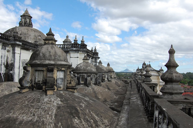
Leon Cathedral was built between 1747 and the early 19th century to the design of Guatemalan architects Diego José de Porres Esquivel, the monument expresses the transition from Baroque to Neoclassical architecture and its style can be considered to be eclectic. The Cathedral is characterized by the sobriety of its interior decoration and the abundance of natural light. The vault of the Sanctuary, however, presents rich ornamentation. The Cathedral houses important works of art including a wooden Flemish altarpiece, and paintings of the 14 stations of the Way of the Cross by Nicaraguan artist Antonio Sarria (late 19th and early 20th centuries).

Leon Cathedral Nicaragua
Continent: North America
Country: Nicaragua
Category: Cultural
Criterion: (II)(IV)
Date of Inscription: 2011

Leon Cathedral Monument

Constructed between 1747 and the early 19th century, León Cathedral merges a basilica rectangular layout of Spanish derivation with regional architectural proportions and features. Stylistically, the monument shows the transition from late Baroque to Neo-Classic with sober decoration. León Cathedral exceptionally illustrates the Antigua Guatemala Baroque architectural style and, in its combination of Spanish art and regional features, shaped by the geographical environment and the groups that supported its erection, is a material expression of the formation of the Latin American society.

The application of the typical quadrangular layout of Spanish origin is outstandingly integrated with architectural features coming from both European Baroque and Neo-classical styles and Antigua Guatemalan interpretation. Among the Antigua features are the mainly horizontal proportions and the low and thick towers as a response to earthquakes, and the internal and external decoration.

Heritage Leon Cathedral Nicaragua
Leon Cathedral Nicaragua

Browse Gallery Plus UNESCO Storyline

Slideshow for this Heritage Site


Browse All UNESCO World Heritage Sites in . The original UNESCO inscription Here!!!

An on-site inspection of Japan’s Kamakura was finished

Members of an advisory body to UNESCO visited Kamakura, Kanagawa Prefecture, on Tuesday to examine whether the ancient city should be added to the list of World Heritage cultural sites. During their on-site inspections, which will last through Thursday, the experts from the International Council on Monuments and Sites are to visit Tsurugaoka Hachimangu Shrine, Enkakuji Temple, the Great Buddha of Kamakura and other cultural assets to assess their value. Based on their findings, the World Heritage Committee will make a final decision on the listing next June. The government formally asked UNESCO in January to register Kamakura and Mount Fuji as World Heritage cultural sites. An on-site inspection of Mount Fuji was conducted this summer.

Want to read UNESCO Daily News Updates? Click

Kamakura

An inspection of KamakuraKamakura is a city located in Kanagawa Prefecture, Japan, about 50 kilometres south-south-west of Tokyo. Although Kamakura proper is today rather small, it is often described in history books as a former de facto capital of Japan as the seat of the Shogunate and of the Regency during the Kamakura Period. Kamakura was designated as a city on November 3, 1939. As of June 1, 2012, the modern city has an estimated population of 174,412 and a population density of 4,400 inhabitants per square kilometre. The total area is 39.60 square kilometres. Kamakura has a beach which, in combination with its temples and proximity to Tokyo, makes it a popular tourist destination.

Browse All UNESCO World Heritage Sites in . The original Source File!!!

Will Vietnam’s Cat Ba get World Heritage Status?

The Ministry of Culture, Sports and Tourism will sign and submit documents of Cat Ba archipelago to UNESCO for recognition as a world natural heritage site. The Prime Minister has assigned the Ministry in collaboration with the UNESCO National Commission of Vietnam to proceed with necessary formalities to submit the documents to the international body. Located in the south of Ha Long Bay, the archipelago has includes 367 islands of different sizes, of which Cat Ba is the largest. The park is home to more than 700 species of flora and fauna, including rare trees and endangered animals. Its forests remain largely untouched. Recently, the Ministry of Culture, Sports and Tourism has decided to rank Cat Ba archipelago in Cat Hai district, Hai Phong city as the national heritage status. This is a meaningful event for Hai Phong which has been preparing for 2013 National Tourism Year of the Red River Delta.

Want to read UNESCO Daily News Updates? Click

Cat Ba Spanning Island

Cat Ba Spanning Island VietnamCat Ba is the largest of the 366 islands spanning 260km2 that comprise the Cat Ba Archipelago, which makes up the south-eastern edge of Ha Long Bay in Northern Vietnam. Cat Ba island has a surface area of 285 km2 and maintains the dramatic and rugged features of Ha Long Bay. It is commonly used as an overnight hotel stop on tours to Ha Long Bay run by travel agents from Hanoi. This island belongs to Haiphong city - the most famous city of industry in Vietnam. The island has a wide variety of natural ecosystems, both marine and terrestrial, leading to incredibly high rates of biodiversity.

Cat Ba Spanning Island

Browse All UNESCO World Heritage Sites in . The original Source File!!!

Wooden houses of Bryggen Norway

Bryggen, the old wharf of Bergen, is a reminder of the town's importance as part of the Hanseatic League's trading empire from the 14th to the mid-16th century. Many fires, the last in 1955, have ravaged the characteristic wooden houses of Bryggen. Its rebuilding has traditionally followed old patterns and methods, thus leaving its main structure preserved, which is a relic of an ancient wooden urban structure once common in Northern Europe. Today, some 62 buildings remain of this former townscape.

Wooden houses of Bryggen Norway
Continent: Europe
Country: Norway
Category: Cultural
Criterion: (III)
Date of Inscription: 1979

Traditional wooden buildings

In its present form, following the 1702 fire, the harmonious ancient quarter of Bryggen illustrates the use of space in district of Hanseatic merchants. It is a type of northern fondaco unequalled by even Lubeck or Novgorod. This part of the town with its traditional wooden buildings perpetuates the memory of one of the oldest large trading ports of northern Europe, and the only one outside the Hanseatic League whose original structures remain within the city limits and cityscape. Founded in about 1070 by King Olav the Peaceful (Olav Kyrre), the port of Bergen was initially a possession of the Old Norwegian aristocracy that had acquired a monopoly on fish trading.

The sagas, such as that of King Sverre (c. 1180) already spoke of the Bryggen district as the base of patrician merchants. About 1350, the powerful Hanseatic League gained control of Bergen and a food packing trade was established not long afterwards. The Bryggen district owes its physiognomy to the German colonists. It is characterized by the construction of buildings along the narrow streets running parallel to the docks.

Wooden houses of Bryggen

Browse Gallery Plus UNESCO Storyline

The urban unit revolves around a courtyard (gard), which is common to several three-level wooden houses whose gabled facades and lateral walls are covered with shingles, as are the roofs. Towards the back of the gård, there is a small warehouse or storeroom (kjellere) of stone which protects the area against fire. This repetitive structure was adapted to the living conditions of the colonists of the hanseatic trading post.

Slideshow for this Heritage Site


The German merchants, who were bachelors, took up winter residence in the small individual wooden houses, and the storeroom was used as an individual or collective warehouse. A true colony, Bryggen enjoyed quasi-extraterritoriality which continued beyond the departure of the Hanseatics until the creation of a Norwegian trading post in 1754 on the impetus of fishermen and shipowners of German origin.

This district, which bears the traces of social organization of space going back to the 14th century, suffered damage over the centuries, some of the most devastating of which being the fires of 1476 and 1702. It nevertheless retains a medieval appearance owing to the fact that it was always reconstructed in accordance with the original plan and using traditional techniques.

In 1955 another fire did extensive damage to the city as a whole, one-third of which was destroyed. Following this last catastrophe, the remaining 58 houses were carefully restored and methodical excavations revealed various levels of occupation, from the 12th to the 18th centuries. On this particular occasion, the variations of the seafront, which contrast with the immutability of the land plot, were studied.

Browse All UNESCO World Heritage Sites in . The original UNESCO inscription Here!!!

Roros Mining Town and the Circumference Norway

Roros is a characteristic example of this type of technological and industrial development, as well as being an outstanding survivor of a traditional kind of human settlement built by traditional methods of construction. Also, it has vulnerable under the impact of economic change since the cessation of copper mining after 333 years of continuous activity. Lastly, Roros embodies a strong degree of rarity because of its location. It was built as an industrial community in the mountains (650 m above sea level) at a very northern latitude subject to extremely long winters and low temperatures (-50 °C).

Roros Mining Town and the Circumference
Continent: Europe
Country: Norway
Category: Cultural
Criterion: (III)(IV) (V)
Date of Inscription: 1980

Beginning of Copper Works

Within the framework of Norway's inventory of cultural property, Roros ranks in importance with Bryggen and the stave church at Urnes. Roros is an extensive mining settlement dating from 1644, when the development of the copper works began. Its physical history has continued without interruption since the town was burned in 1679.

Thus the numerous surviving buildings represent the Norwegian tradition of construction that flourished in the 18th and 19th centuries. The buildings reflect the dual occupations of the inhabitants - mining and farming - the domestic groups being arranged as compact farmyards. These groups are disposed on a regular urban pattern adapted to the mountain terrain, reflecting the particular kind of industrial planning introduced by the Danish kings of Norway in the 16th and 17th centuries.

Roros Mining Town and the Circumference Norway
Roros Mining Town

Browse Gallery Plus UNESCO Storyline

Slideshow for this Heritage Site


Roros is in a remarkably complete state of preservation. An engraving of the town as seen from the slag heaps in the 1860s is virtually the same as a photograph of the 1970s taken from the same viewpoint.

Preservation efforts date from the early years of the 20th century. The first legal protection of buildings in Roros was effected in 1923. Legal protection now extends to 80 buildings. In 1936 land was purchased for the development of an open-air museum, and the first old building was moved to the site in 1947. However, the museum impetus was overtaken by a movement, dating from 1938, that led to the preparation of plans for the preservation of the town and copper works in situ.

Browse All UNESCO World Heritage Sites in . The original UNESCO inscription Here!!!

West Norwegian Fjords Norway

Situated in south-western Norway, north-east of Bergen, Geirangerfjord and Naoyfjord, set 120 km from one another, are part of the west Norwegian fjord landscape, which stretches from Stavanger in the south to Andalsnes, 500 km to the north-east. The two fjords, among the world's longest and deepest, are considered as archetypical fjord landscapes and among the most scenically outstanding anywhere. Their exceptional natural beauty is derived from their narrow and steep-sided crystalline rock walls that rise up to 1,400 m from the Norwegian Sea and extend 500 m below sea level. The sheer walls of the fjords have numerous waterfalls while free-flowing rivers cross their deciduous and coniferous forests to glacial lakes, glaciers and rugged mountains. The landscape features a range of supporting natural phenomena, both terrestrial and marine, such as submarine moraines and marine mammals.

West Norwegian Fjords Norway
Continent: Europe
Country: Norway
Category: Natural
Criterion: (VII)(VIII)
Date of Inscription: 2005

The world's longest and deepest fjords

The two fjords, among the world's longest and deepest, are considered as archetypical fjord landscapes and among the most scenically outstanding anywhere. Their exceptional natural beauty is derived from their narrow and steep-sided crystalline rock walls that rise up to 1,400 m from the Norwegian Sea and extend 500 m below sea level. The sheer walls of the fjords have numerous waterfalls, while free-flowing rivers cross their deciduous and coniferous forests to glacial lakes, glaciers and rugged mountains. The landscape features a range of supporting natural phenomena, both terrestrial and marine such as submarine moraines and marine mammals.

Remnants of old and now mostly abandoned transhumant farms add a cultural aspect to the dramatic natural landscape that complements and adds human interest to the area.

World Heritage West Norwegian Fjords Norway
West Norwegian Fjords Norway

Browse Gallery Plus UNESCO Storyline

Slideshow for this Heritage Site


Browse All UNESCO World Heritage Sites in . The original UNESCO inscription Here!!!

#930 Shark and Ray Alley, Caye Caulker, Belize

Just off Caye Caulker, south of Ambergris Caye, in Belize's off-shore coral reef, is the Hol Chan Marine Reserve, and one of it's special features is a snorkelling site called Shark (and) Ray Alley. The reason it is so called is because it's almost guaranteed that you will see sharks and rays when you visit! Beautiful nurse sharks either circle around you  or sleep on the ocean floor. Southern sting rays hide on the sandy bottom or float gracefully past. All this in only a couple of meters of water!

Some videos!


Sub-Antarctic Islands New Zealand

The New Zealand Sub-Antarctic Islands consist of five island groups located in the Pacific sector of the Southern Ocean off the south-eastern coast of New Zealand. Along with the Macquarie Island World Heritage site in Australia, the five islands form the only subantarctic island group in the region. The islands lie between latitudes of 47º and 52º south and include the Snares, Bounty Islands, Antipodes Islands, Auckland Islands and Campbell Islands. Total land area is 76,458 ha. The site includes a marine component extending 12 km from each island group.

Sub-Antarctic Islands New Zealand
Continent: Oceania
Country: New Zealand
Category: Natural
Criterion: (IX)(X)
Date of Inscription: 1997

Few hours of sunshine and high humidity

The islands lie on the shallow continental shelf and three of the groups are eroded remnants of Pliocene volcanoes. Rivers are short with precipitous streams. The lakes are few and generally shallow and small. Quaternary glaciers have left shallow cirques, moraines and fjords on some islands. Cool equable temperatures, strong westerly winds, a few hours of sunshine and high humidity prevail.

With the exception of the Bounty Islands which have no higher plants, the remaining islands together with neighbouring Macquarie Island, constitute a Centre of Plant Diversity and have the richest flora of all the subantarctic islands. The Snares and two of the Auckland Islands are especially important in that their vegetation has not been modified by human or alien species. The terrestrial flora of the islands comprises 233 vascular plants of which 196 are New Zealand Sub-Antarctic Islands (New Zealand) indigenous, six endemic, and 30 are rare. Auckland Islands have the southernmost forests in the region, dominated by a species of myrtle. A particular floral feature of the islands is the 'megaherbs' that contribute to rich and colourful flower gardens.

Sub-Antarctic Islands
Penguin atSub-Antarctic Islands

Browse Gallery Plus UNESCO Storyline

Slideshow for this Heritage Site


As the islands lie between the Antarctic and Subtropical Convergences, the seas have a high level of productivity. The Islands are particularly notable for the huge abundance and diversity of pelagic seabirds and penguins that nest there. There are 120 bird species in total, including 40 seabirds of which five breed nowhere else. The islands support major populations of 10 of the world's 24 species of albatross. Almost 6 million sooty shearwaters nest on Snares Island alone. There are also a large number of threatened endemic land birds including one of the world's rarest ducks. 95% of the world's population of New Zealand sea lion (formerly known as Hooker's sea lion) breed here and there is a critical breeding site for the southern right whale. A number of endemic invertebrates also occur.

Browse All UNESCO World Heritage Sites in . The original UNESCO inscription Here!!!

The birthplace of the Gautama Buddha Lumbini Nepal

As the birthplace of the Lord Buddha - the apostle of peace and the light of Asia was born in 623 BC - the sacred area of Lumbini is one of the holiest places of one of the world's great religions, and its remains contain important evidence about the nature of Buddhist pilgrimage centres from a very early period. Lumbini, in the South-Western Terai of Nepal, evokes a kind of holy sentiment to the millions of Buddhists all over the world, like Jerusalem to Christians and Mecca to Muslims.

The birthplace of the Gautama Buddha Lumbini Nepal
Continent: Asia
Country: Nepal
Category: Cultural
Criterion: (III)(VI)
Date of Inscription: 1997

Gifted Lumbini

Lumbini is the place where the Buddha, known as the Tathagata, was born. It is the place which should be visited and seen by a person of devotion and which should cause awareness and apprehension of the nature of impermanence. The site and its surrounding area is endowed with a rich natural setting of domesticable fauna and favourable agricultural environ. Historically, the region is an exquisite treasure-trove of ancient ruins and antiquities, dating back to the pre-Christian era. The site, described as a beautiful garden in the Buddha's time, still retains its legendary charm and beauty.

The birthplace of the Gautama Buddha, Lumbini, is one of the four holy places of Buddhism. It is said in the Parinibbana Sutta that Buddha himself identified four places of future pilgrimage: the sites of his birth, Enlightenment, First Discourse, and death. All these events happened outside in nature under trees. There is no particular significance in this, other than it perhaps explains why Buddhists have always respected the environment and natural law.

The birthplace of the Gautama Buddha Lumbini
The birthplace of the Gautama Buddha

Browse Gallery Plus UNESCO Storyline

Lumbini is situated at the foothills of the Himalayas in modern Nepal. In the Buddha's time, Lumbini was a beautiful garden full of green and shady sal trees (Shorea robusta ). The garden and its tranquil environs were owned by both the Shakyas and the clans. King Suddhodana, father of Gautama Buddha, was of the Shakya dynasty and belonged to the Kshatriya (warrior caste). Maya Devi, his mother, gave birth to the child on her way to her parent's home in Devadaha while resting in Lumbini under a sal tree in the month of May, 642 BC.

The beauty of Lumbini is described in Pali and Sanskrit literature. Maya Devi, it is said, was spellbound to see the natural grandeur of Lumbini. While she was standing, she felt labour pains and catching hold of a drooping branch of a sal tree, she gave birth to a baby, the future Buddha.

Slideshow for this Heritage Site


In 249 BC, when the Nepaln Emperor Ashoka visited Lumbini, it was a flourishing village. Ashoka constructed four stupas and a stone pillar with a figure of a horse on top. The stone pillar bears an inscription, which in translation runs as follows: 'King Piyadasi (Ashoka), beloved of devas, in the 20th year of the coronation, himself made a royal visit, Buddha Sakyamuni having been born here; a stone railing was built and a stone pillar erected to the Bhagavan having been born here, Lumbini village was taxed reduced and entitled to the eight part (only)'.

Lumbini remained neglected for centuries. In 1895, Feuhrer, a famous German archaeologist, discovered the great pillar while wandering about the foothills of the Churia range. Further exploration and excavation of the surrounding area revealed the existence of a brick temple and sandstone sculpture within the temple itself, which depicts the scenes of the Buddha's birth.

It is pointed out by scholars that the temple of Maya Devi was constructed over the foundations of more than one earlier temple or stupa, and that this temple was probably built on an Ashokan stupa itself. To the south of the Maya Devi temple there is the famous sacred bathing pool known as Puskarni. It is believed that Maya Devi took a bath in this pool before the delivery. By the side of the Ashoka pillar a river which flows south-east and is locally called the Ol. In 1996, an archaeological dig unearthed a 'flawless stone' placed there by Ashoka in 249 BC to mark the precise location of the Buddha's birth more than 2,600 years ago. if authenticated, the find will put Lumbini even more prominently on the map for millions of religious pilgrims.

Browse All UNESCO World Heritage Sites in . The original UNESCO inscription Here!!!

World Heritage W National Park of Niger

The part of 'W' National Park that lies in Niger is situated in a transition zone between savannah and forest lands and represents important ecosystem characteristics of the West African Woodlands/Savannah Biogeographical Province. The site reflects the interaction between natural resources and humans since Neolithic times and illustrates the evolution of biodiversity in this zone. The 'W' National Park, so named because of the local configuration of the Niger River (220,000 ha), is located in a transition zone between Sudan and Guinea savannahs and contiguous to 'W' National Parks in both Burkina Faso and Benin, and the Reserve de Faune de Tamou to the north. Shrub savannah is the most widespread vegetation type occurring on shallow infertile soils.

World Heritage W National Park of Niger
Continent: Africa
Country: India
Category: Natural
Criterion: (IX)(X)
Date of Inscription: 1996

'W' Hosts Ecosystems

W hosts ecosystems representing the interaction between natural resources and humans since Neolithic times. This interaction has produced characteristic landscapes and plant formations and represents the evolution of biodiversity in the Sudan-Sahelian biome. The park hosts the major populations of ungulates in West Africa and wild plant species considered very important for conservation and genetic research. The wetland area of the park is of international importance for the conservation of birds as a Ramsar site. The fact that the park is contiguous to other protected areas in Burkina Faso and Niger is important for the survival of species that need large areas for their seasonal migrations.

A total of 454 plant species has been recorded, including two orchid species found only in Niger. More than 70 mammal species have been described, and around 350 bird species are found in the area. Most of the populations of ungulate species are increasing, thanks to protection programmes. Reptiles and fishes occurring in the park are typical of the Niger River.

W National Park of Niger

Browse Gallery Plus UNESCO Storyline

Slideshow for this Heritage Site


Browse All UNESCO World Heritage Sites in . The original UNESCO inscription Here!!!