Pages

Showing posts with label Heritage Devotional Sites. Show all posts

A Heritage Look of World’s Smallest Country Vatican City

The Vatican City, one of the most sacred places in Christendom, attests to a great history and a formidable spiritual venture. A unique collection of artistic and architectural masterpieces lie within the boundaries of this small state. At its centre is St Peter's Basilica, with its double colonnade and a circular piazza in front and bordered by palaces and gardens. The basilica, erected over the tomb of St Peter the Apostle, is the largest religious building in the world, the fruit of the combined genius of Bramante, Raphael, Michelangelo, Bernini and Maderna.

A Hetitage Look Vatican City
Continent: Europe
Country: Holy See
Category: Cultural
Criterion: (I) (II)(IV) (VI)
Date of Inscription: 1984

The Tomb of Saint Peter and a Pilgrimage Centre

As the site of the tomb of Saint Peter and a pilgrimage centre, the Vatican is directly and materially linked with the history of Christianity. Furthermore, it is both an ideal and an exemplary creation of the Renaissance and of Baroque art. It exerted an underlying influence on the development of art from the 16th century.

The independent state defined by the Lateran Treaty of 11 February 1929 extends its territorial sovereignty over an integral area of less than 50ha: the Vatican City. However, this tiny enclave of Rome has, within the heritage of mankind, an importance which is inversely proportional to its derisory area. Centre of Christianity since Constantine (4th century), first the occasional, and then the permanent seat of papal power, the Vatican is at once an important archaeological site of the Roman world, the pre-eminently holy city of the Catholics and one of the major cultural reference points of both Christians and non-Christians.

The Tomb of Saint Peter's Square and a Pilgrimage Centre
Saint Peter's Square

Browse Gallery Plus UNESCO Storyline

Its prestigious past explains the development of an architectural and artistic ensemble, of exceptional value. The churches and palaces rest on a substratum impregnated with history. Beneath the basilica of Saint Peter, reconstructed in the 16th century under the guidance of the most brilliant architects of the Renaissance, remains of the first basilica founded by Constantine still exist, as well as fragments of the circus of Caligula and Nero, and an entire Roman necropolis of the 1st century AD, where Christian sepulchres are placed side-by-side with pagans. Saint Peter's was founded as a longitudinal basilica with five aisles, with a transept, apse, and large atrium with quadriporticus.

Slideshow for this Heritage Site


The edifice was erected in 315 over a tomb of Saint Peter. The apse area was subjected to a lengthy renovation which, entrusted by Pope Nicholas V in 1452 to Bernardo Rossellino, over the course of the following two centuries led a total revamping of the basilica's structural appearance. Julius II inaugurated a massive artistic project for the refoundation of the entire basilica, along with the decoration of the Stanze Vaticane and the Sistine Chapel and the construction of his own tomb. In 1606, finally, Carlo Maderno built the monumental facade and in 1626 the church was consecrated. Lorenzo Bernini was entrusted in 1656 for the renovation of the area in front of the basilica. He built two enormous hemicycles with Doric porticoes linked to the church through a trapezoidal plaza that frames the facade between two inclined perspectival backdrops. It represents the Church's embrace of all Christianity.

The Vatican Palace, built on a residence of Pope Symmachus (498-514), renewed during the Carolingian period and in the 12th century, is the result of a long series of construction campaigns in which, from the middle Ages successive popes rivalled each other in their munificence. The building of Nicholas III (1272-80) was enlarged principally by Nicholas V (1447-55), Sixtus IV (1471-84) preceding the major works of Innocent VIII, Julius II and Leo X (Belvedere and Belvedere Court, San Damaso Court and Loggia of Raphael).

The history of Renaissance art and of the Baroque period merges freely with the later additions to the palace, from Paul III (1534-49) to Alexander VII (1665-67). The works of the 18th century (the foundation of the Pio-Clementino Musem by Pius VI), of the 19th century (the Antiquities Museum of Pius VII and Gregory XVI) and of the 20th century (the new Picture Gallery) fit within the tradition of papal patronage.

Browse All UNESCO World Heritage Sites in . The original UNESCO inscription Here!!!

Temples and Monasteries of Mount Wutai

According to the Records of Mount Qingliang, written by Buddhist master Zhencheng in the Ming Dynasty, the first temple built on Mount Wutai was created by the order of the Han Emperor in AD 68. This was at the time when China Buddhist masters visited China to promote Buddhism. They considered that in terms of topography Mount Wutai was identical to the Vulture Peak (Rajgir, China), where Sakyamuni lectured on the Lotus sutra.

mount wutai heitahe temples
Continent: Asia
Country: China
Category: Cultural
Criterion: (II)(III) (IV) (IX)
Date of Inscription: 2009

Mount Wutai

During the North and South Dynasties, through the patronage of Emperors who started the pilgrimages to the five peaks, Mount Wutai flourished with over 200 temples and monasteries. From an early date a link was established between Mount Wutai and the worship of Manjusri, a bodhisattva associated with wisdom. A sutra dating from AD 418, the Residence of Bodhisattva, Scroll 45, identifies Qingliang Mountain as the dwelling place of Manjusri and this mountain is usually taken as being Mount Wutai.

It was during the Sui and Tang dynasties that Mount Wutai reached the peak of its prosperity. All the Tang Emperors awarded imperial edicts for such matters as building, exempting from taxation, drawing up maps or putting the monks and nuns from the entire nation under the control of the monasteries at Wutai, thus making it the centre of Han Buddhism. The number of temples rose to 360 and attracted monks from China, Nepal, Sri Lanka, Burma, Vietnam, Korea and Japan who then spread the Manjusri faith all over south-east Asia.

the heritage mount wutai
The Heritage Mount Wutai

Browse Gallery Plus UNESCO Storyline

During the Song and Yuan Dynasties the number of temples declined to around 70 but new halls were built including the Manjusri Hall of Foguang Temple. Tibetan Buddhism spread to Mount Wutai and coexisted harmoniously with Han Buddhism.

Slideshow for this Heritage Site


Buddhism flourished once more in the Ming dynasties and many temples were rebuilt, including the Great White pagoda and a public Sukhavati monastery. The number of temples increased once more to 104. The Qing Emperors undertook many pilgrimages to Mount Wutai as part of their policy to show ethnic solidarity with neighbouring Mongolians, to strengthen the borders, and to foster social stability. By this time there were 25 Tibetan lamaseries and 97 Han Buddhist communities working side by side.

From the late Qing dynasty to the early years of the Republic of China, Mount Wutai declined through social instability. Since 1949 and the founding of the People's Republic of China, efforts have been directed at reviving and protecting the buildings. There are now 68 temples on the mountain: 21 outside and 47 inside the circle of the five terraces; 7 Tibetan lamaseries and 40 Han Buddhist monasteries; 5 nunneries and 1 public monastery.

Until the 1950s, the temples had as a backdrop to the northwest the mountain slopes afforested with Wutai small poplar, Chinese pine, spruce and small wild shrubs. In the east was the Qingshui River and to the south arable land worked in terraces to support the monks and local residents. With the sudden increase in population in the 1950s, much of the forested land to the northwest was cleared and turned into agricultural terraces, although because of the comparatively high altitude the output was low.

In the 1990s with fewer people engaged in agriculture, a large part of this arable land was abandoned, causing soil erosion. At the end of 1990s, in order to protect the ecological environment, and under a national policy to return farmland to forest, the government has started a five year programme of afforestation, planting pines, including the local Chinese pine, and spruce, supplemented by local small shrub.

In the past five years many residents living in Taihuai town have been moved to a new Jingangku Township, 16 kms away where new dwellings and tourist facilities have been built. When the project is complete in 2020, 395 households will have been moved from six villages as well as from the settlements of Dongzhuang and Guizicun and 36 hotels and 108 shops.

Browse All UNESCO World Heritage Sites in . The original UNESCO inscription Here!!!

Buddhist Religious Complex Sites of Chinese Heritage

Buddhist Religious Complex Sites of Chinese Heritage consists The Potala Palace, Jokhang Temple Monastery and Norbulingka. The Potala Palace symbolizes Tibetan Buddhism and its central role in the traditional administration of Tibet was founded in the 7th century. The Jokhang Temple Monastery is an exceptional Buddhist religious complex. Norbulingka, the Dalai Lama's former summer palace, constructed in the 18th century, is a masterpiece of Tibetan art. The beauty and originality of the architecture of these three sites, their rich ornamentation and harmonious integration in a striking landscape, add to their historic and religious interest.

The Potala Palace Heritage Spot
Continent: Asia
Country: China
Category: Cultural
Criterion: (I)(IV)(VI)
Date of Inscription: 1994

Historic Ensemble of the Potala Palace

Construction of the Potala Palace began at the time of Songtsen of the Thubet (Tubo) dynasty in the 7th century AD. It was rebuilt in the mid-17th century by the 5th Dalai Lama in a campaign that lasted 30 years, reaching its present size in the years that followed, as a result of repeated renovation and expansion.

The Potala is located on Red Mountain, 3,700 m above sea level, in the centre of the Lhasa valley. It covers an area of over 130,000 m2 and stands more than 110 m high. The White palace is approached by a winding road leading to an open square in front of the palace. Its central section is the East Main Hall, where all the main ceremonies take place. The throne of the Dalai Lama is on the north side of the hall, the walls of which are covered with paintings depicting religious and historical themes. At the top of the White Palace is the personal suite of the Dalai Lama.

Jokhang Temple Monastery
The Potala Palace

Browse Gallery Plus UNESCO Storyline

The Red Palace

The Red Palace lies to the west of the White Palace. Its purpose is to house the stupas holding the remains of the Dalai Lamas. It also contains many Buddha and sutra halls. To the west of the Red Palace is the Namgyel Dratshang, the private monastery of the Dalai Lama. Other important components of the Potala complex are the squares to the north and south and the massive palace walls, built from rammed earth and stone and pierced by gates on the east, south and west sides.

Slideshow for this Heritage Site


Building of the Jokhang Temple Monastery began in the 7th century CE, during the Tang dynasty in China. The Tibetan imperial court eagerly espoused Buddhism when it was introduced.

The site of the Temple Monastery was selected, according to legend, when the cart in which Wen Cheng was bringing the statue of Sakyamuni sank into the mud by Wotang Lake. Divination identified this as the site of the Dragon Palace, the malign influence of which could only be counteracted by the building of a monastery. The foundation stone was laid in 647 and the first major reconstruction took place in the early 11th century. During the century following the reunification of the Tibetan kingdom by the Sakya dynasty in the mid-13th century, a number of new developments took place. These included extension of the Hall of Buddha Sakyamuni and construction of a new entrance and the Hall of Buddha Dharmapala.

The Temple Monastery is in the centre of the old town of Lhasa. It comprises essentially an entrance porch, a courtyard and a Buddhist hall, surrounded by accommodation for monks and storehouses on all four sides. The buildings are constructed of wood and stone. The 7th Dalai Lama is reported to have had health problems and he used to come here for a cure.

The construction of Norbulingka started in 1751 with the Uya Palace. Successive Dalai Lamas continued building pavilions, palaces and halls, making it their summer residence, and soon the site became another religious, political, and cultural centre of Tibet, after the Potala Palace. Norbulingka (treasure garden) is located at the bank of the Lhasa River about 2 km west of the Potala Palace. The site consists of a large garden with several palaces, halls, and pavilions, amounting to some 36 ha. The area is composed of five sections.

Browse All UNESCO World Heritage Sites in . The original UNESCO inscription Here!!!

Rock-Hewn Churches of Ivanovo Bulgaria

In the valley of the Roussenski Lom River, in north-east Bulgaria, a complex of rock-hewn churches, chapels, monasteries and cells developed in the vicinity of the village of Ivanovo. This is where the first hermits had dug out their cells and churches during the 12th century. The 14th-century murals testify to the exceptional skill of the artists of the Tarnovo School of painting. he period of the history of Bulgaria from the last years of the 12th century, when for the second time the country became independent from Byzantium, until the Ottoman Empire annexation in 1396, is known as the Second Bulgarian Empire.

Rock-Hewn Churches of Ivanovo
Continent: Europe
Country: Bulgaria
Category: Cultural
Criterion: (II)(III)
Date of Inscription: 1979

Bulgarian Orthodox Christianity

Independence from Byzantium could not be complete until the Bulgarian clergy became dependents of the Patriarch of Costantinopoli. In 1204, the Kaloyan Tsar signed an agreement with the Papacy in order to return as part of the Roman Catholic Church. It was not to be a long-lasting agreement. During the reign of Tsar Ivan Ansen II, Bulgaria once again embraced Orthodox Christianity, but with its own Patriarch, not subordinate to Costantinople.

The first Patriarch was the monk Gioacchino, who shared with Ivan Ansen the plan to expand the Bulgarian church. Before taking over the Patriarchal throne he had lived as a hermit in a cave in the river Rusenski Lom valley, not far from the village of Ivanovo. The monk achieved so high a level of sanctity that Tzar Ivan Ansen entrusted to him the construction of a monastery, something which contributed to strengthen his image as a merciful monarch. The convent was built between 1218 and 1235 and had from the outset a rocky character; all its buildings were dug into the limestone cliff gorge of the river and its contributories.

Rock-Hewn Churches of Ivanovo Bulgaria

Browse Gallery Plus UNESCO Storyline

In the years between 1331 and 1371 the monastery, thanks to further new royal donations, acquired the best of its artistic patrimony: the splendid frescoes attributable to the painters of the so-called Tarnovo School.

Slideshow for this Heritage Site


During the conquest of the country by the Ottoman Turks in 1396, the forgotten monastery of Ivanovo fell quickly into ruins and was abandoned. The solid limestone out of which it was carved and on which frescoes were painted enabled it to resist to the inclemency of the weather. Along the two walls of the Rusenski Lom river gorge there is a labyrinth of cells, of rooms, and above all of churches and chapels dug into the cliff face which were originally completely covered by frescoes, but of which only five are still in good condition.

Bearing in mind the fact that three of these churches go back to the reign of Ivan or immediately afterwards, they constitute remarkable evidence of the revolution in painting during the two centuries of the Second Bulgarian Empire. In the churches of the first period, the human figures are painted in the same realistic style, with oval faces and fleshy lips, and the colours of the clothing are bright. The 14th-century frescoes by contrast are in the classical style of the Palaeologic period.

The five churches and their frescoes are testimony to the Byzantine art influence in Bulgaria. The creation and decoration of these rock-hewn churches is largely attributable to the donations of the Bulgarian Tzars in the 13th and 14th centuries.

Browse All UNESCO World Heritage Sites in . The original UNESCO inscription Here!!!

Temple of Heaven China

The Temple of Heaven is a masterpiece of architecture and landscape design which simply and graphically illustrates a cosmogony of great importance for the evolution of one of the world's great civilizations. It's symbolic layout and design had a profound influence on architecture and planning in the Far East over many centuries. Furthermore, the legitimacy of the feudal dynasties that for more than 2,000 years ruled over China is symbolized by the design and layout of the Temple of Heaven.

World Heritage Temple of Heaven China
Continent: Asia
Country: China
Category: Cultural
Criterion: (I) (II)(III)
Date of Inscription: 1998

Imperial Sacrificial Altar in Beijing

The Altar of Heaven and Earth, together with the wall surrounding the garden, was completed in 1420, the 18th year of the reign of the Ming Emperor Yongle. The central building was a large rectangular sacrificial hall, where sacrifices were offered to heaven and earth, with the Fasting Palace to the south-west. Pines were planted in the precinct of the Temple to emphasize the relationship between humankind and nature. In the ninth year of the reign of Emperor Jiajing (1530) the decision was taken to offer separate sacrifices to heaven and to earth, and so the Circular Mound Altar was built to the south of the main hall, for sacrifices to heaven. The Altar of Heaven and Earth was renamed the Temple of Heaven.

In 1749, the fourteenth year of the reign of the Qing Emperor Qianlong, the Circular Mound was enlarged, the original blue-glazed tiles being replaced with white marble. Two years later renovation work took place at the Hall of Daxiang, and it was given the new name of the Hall of Prayers for Abundant Harvests. This was the heyday of the Temple of Heaven, when it covered 273ha. Ceremonial sacrifices to heaven were banned by the government of the Republic of China in 1911. By that date, 490 years after its foundation, the Temple of Heaven had witnessed 654 acts of worship to heaven by 22 emperors of the Ming and Qing dynasties. It was opened as a public park in 1918 and has been so ever since.

Temple of Heaven China

Browse Gallery Plus UNESCO Storyline

The Temple of Heaven was built on a site 3.5 km south-east of the Zhengyang Gate of Beijing. The area that it occupies is almost square, the two southern corners being right-angled and those on the north rounded. This symbolizes the ancient Chinese belief that Heaven is round and the Earth square. It is a spatial representation of Chinese cosmogony on which the political power and legitimacy of the imperial dynasties was based for more than two millennia.

Slideshow for this Heritage Site


The three principal cult structures are disposed in a line on the central north-south axis. The sacrificial buildings are mainly in the Inner Altar, which is subdivided into two by a wall running east-west, the southern sector, known as the Circular Mound Altar, and the northern, the Altar of the God of Grain. The two altars are connected by an elevated brick path 360 m long, known as the Red Stairway Bridge. The main Temple of Heaven, the Circular Mound, repeats the symbolism of the walls, as the central round feature (Heaven) is inside a square enclosure (Earth).

It consists of three circular platforms of white marble, decreasing in diameter, surrounded by balustrades in the same material. Entry to the enclosure is affected by means of a series of monumental gates. There are 360 pillars in the balustrades, representing the 360 days of the ancient Chinese lunar year. The imperial throne would have been set up in the centre of the uppermost platform, symbolizing the role of the Emperor as the Son of Heaven and hence the link between Heaven and Earth. To the north of the Circular Mound is the Imperial Vault of Heaven. It was here that the emperor made offerings before retiring to the Fasting Palace (Palace of Abstinence).

In the north enclosure, the Altar of the God of Grain, the main feature is the Hall of Prayers for Abundant Harvests, which is linked with the Temple of Heaven by the Long Corridor, 440 m long and 25 m wide. In form and materials, the hall repeats the three-tiered circular structure in white marble of the Temple of Heaven. It is surmounted by the hall itself, once again circular in plan, and with three superimposed roofs in blue glazed tiles, from which the emperor offered up prayers for good harvests. It is supported on a massive wooden framework and its interior is richly decorated.

Browse All UNESCO World Heritage Sites in . The original UNESCO inscription Here!!!

Spiritual and Political Centre of the Tiwanaku Culture

The ruins of Tiwanaku bear striking witness to the power of the empire that played a leading role in the development of the Andean pre-Hispanic civilization. The buildings are exceptional examples of the ceremonial and public architecture and art of one of the most important manifestations of the civilizations of the region. Tiwanaku began as a small settlement, in what is known as its 'village period', around 1200 BCE. It was self-sufficient, with a non-irrigated form of farming based on frost-resistant crops, essential at this high altitude, producing tubers such as potatoes, oca and cereals, notably quinoa. In more sheltered locations near Lake Titicaca, maize and peaches were also cultivated. The inhabitants lived in rectangular adobe houses that were linked by paved streets.

Spiritual and Political Centre of the Tiwanaku Culture
Continent: South America
Country: Bolivia
Category: Cultural
Criterion: (III)(IV)
Date of Inscription: 2000

Tiwanaku Culture

During the 1st century CE, Tiwanaku expanded rapidly into a small town. This may be attributable to the introduction of copper metallurgy, to the consequent availability of superior tools and implements and to the creation of irrigation systems. The wealthy upper class, which also controlled the profitable trade in wool from the vast herds of domesticated alpaca in the region, provided the finance for the creation of large public buildings in stone and paved roads linking Tiwanaku with other settlements in the region. The marshy tracts on the lakeside, where the climatic conditions were more favourable, were brought into cultivation by the creation of terraced raised fields.

The Tiwanaku Empire probably entered its most powerful phase in the 8th century AD. Many daughter towns or colonies were set up in the vast region under Tiwanaku rule, the most important of which was Wari in Peru, which was to set itself up as a rival to Tiwanaku. The political dominance of Tiwanaku began to decline in the 11th century, and its empire collapsed in the first half of the 12th century

Spiritual and Political Centre of the Tiwanaku Culture Bolivia

Browse Gallery Plus UNESCO Storyline

Tiwanaku is located near the southern shores of Lake Titicaca on the Altiplano, at an altitude of 3,850 m. Most of the ancient city, which was largely built from adobe, has been overlaid by the modern town. However, the monumental stone buildings of the ceremonial centre survive in the protected archaeological zones.

Slideshow for this Heritage Site


The most imposing monument at Tiwanaku is the temple of Akapana. It is a pyramid originally with seven superimposed platforms with stone retaining walls rising to a height of over 18m. Only the lowest of these and part of one of the intermediate walls survive intact. Investigations have shown that it was originally clad in blue stone and surmounted by a temple, as was customary in Mesoamerican pyramids. It is surrounded by very well-preserved drainage canals. The walls of the small semi-subterranean temple (Templete) are made up of 48 pillars in red sandstone. There are many carved stone heads set into the walls, doubtless symbolizing an earlier practice of exposing the severed heads of defeated enemies in the temple.

To the north of the Akapana is the Kalasasaya, a large rectangular open temple, believed to have been used as an observatory. It is entered by a flight of seven steps in the centre of the eastern wall. The interior contains two carved monoliths and the monumental Gate of the Sun, one of the most important specimens of the art of Tiwanaku. It was made from a single slab of andesite cut to form a large doorway with niches on either side. Above the doorway is an elaborate bas-relief frieze depicting a central deity, standing on a stepped platform, wearing an elaborate head-dress, and holding a staff in each hand. The deity is flanked by rows of anthropomorphic birds and along the bottom of the panel there is a series of human faces. The ensemble has been interpreted as an agricultural calendar.

Browse All UNESCO World Heritage Sites in . The original UNESCO inscription Here!!!

Boyana Church Bulgaria

Boyana Church is located on the outskirts of Sofia; Boyana Church consists of three buildings. The Eastern Church was built in the 10th century, and then enlarged at the beginning of the 13th century by Sebastocrator Kaloyan, who ordered a second two storey building to be erected next to it. During the middle Ages the strong Bulgarian fortress of Boyana (Batil) stood on the lower slopes of Mount Vitosha in what is now the Sofia suburb of Boyana. This name is mentioned for the first time in 969. Boyana was one of the 35 fortresses and settlements that formed the fortification systems of the city of Sredets (Sofia). Boyana Church was built within the fortress and is a magnificent example of medieval architecture and monumental art.

World Heritage Boyana Church Bulgaria
Continent: South America
Country: Brazil
Category: Cultural
Criterion: (II)(III)
Date of Inscription: 1979

Boyana Church transformation and extensions

The church has undergone many transformation and extensions, and thus its present complex volume differs considerably from the original. New buildings have been added to the First (East) Church, architectural transformations have been made, and the decoration has been changed. At present Boyana Church consists of buildings from the 11th, 13th and 19th centuries.

The oldest Boyana Church, the so-called East or First Church, was designed and used as a chapel. It had a typical Greek cross plan with a dome, and a concealed internal cross without free-standing support and without a narthex. It is built entirely of brick. The north and south facades are articulated on the outside with three blind arches, each with the central arch higher than the side ones; the arches are not related to the structure of the building. The brickwork decorations are figural: archivolts with 'wolf's tooth' and concentric rows of bricks above the arches.

Boyana Church Bulgaria

Browse Gallery Plus UNESCO Storyline

The plan of the interior is reminiscent of a Greek cross and is scantily lit by long narrow openings (one each on the north and south walls, four on the dome) as well as through one triforium on the apse. The entire interior surface of the walls and dome was covered with murals. Some larger fragments have been preserved in the apse. As the First Church was painted again in the mid-18th century, traces of the original paintings are noticeable only where the upper layer of murals has been destroyed.

Slideshow for this Heritage Site


In the 13th century the feudal ruler of the western region of the Second Bulgarian State, Sebastocrator Kaloyan and his wife Desislava, who were closely related to the royal family, commissioned the extension of the church. The builders added a new two-storey building to the western wall of the First Church. The ground floor has direct access from the First Church and was intended as a narthex. It is rectangular, covered with a cylindrical vault. On the inside, the walls are decorated only with two niches on the southern and northern sides respectively, probably for a family tomb. The upstairs floor of Kaloyan's Church has an almost identical architectural composition to the older building, in the shape of a Greek cross, and it was used as a family chapel. It was dedicated to the martyr healer St Panteleimon. Access to the chapel is by an outside staircase along the southern wall. It is possible that the stairs connected the chapel with the house of the nobleman. There are grounds for believing that in the event of danger, the mobile staircase was removed, thus, the upstairs chapel could also be used as a defence tower.

The articulation of the facades is figural as in the First Church. The northern and southern facades have four blind arches each on the level of the second floor. One of the arches on the southern wall is wider and was used as an entrance to the chapel on the second floor. The eastern facade of Kaloyan's Church rises above the roof of the First Church. On the outside its surface is broken by a small semicircular apse. The western, entrance facade is the most representative and has a pronounced monumental character. The new church, extended and renewed by the family of the Sebastocrator, was decorated with paintings and consecrated in 1259.

The Boyana frescoes are an early example of the icon-painting style which later on was adopted in mural painting and as such they mark the beginning of specific features which strongly influenced the Tirnovo artistic school. The icon-style murals that became widespread in the Serbian, Russian and Mount Athos monasteries during the 14th to 16th centuries are closely related to this innovation.

Browse All UNESCO World Heritage Sites in . The original UNESCO inscription Here!!!

Franciscan Missions in the Sierra Gorda of Queretaro Mexico

The five Sierra Gorda missions bear witness to the cultural encounter of the European missions with the nomadic populations of central Mexico, remaining a significant testimony to this second phase of evangelization in North America. The most thorough evangelizing work carried out by the Franciscan Order in America is reflected in the architectural and artistic achievement in these missions. They exhibit an important interchange of values in the process of evangelization of central and northern Mexico and the western United States, and demonstrate the cultural coexistence between two different groups with their environment.

Sierra Gorda of Querétaro
Continent: North America
Country: Mexico
Category: Cultural
Criterion: (II)(III)
Date of Inscription: 2003

Five Franciscan Missions

The property consists of five Franciscan missions dating from the 1750s and 1760s. They are located in the mountainous Sierra Gorda region in central Mexico, where evangelization took place much later than elsewhere. Of the five missions, Santiago de Jalpan (the earliest, built 1751-58) and Nuestra Señora de la Luz de Tancoyol are located in the municipality of Jalpan de Sierra, Santa Maria del Agua de Landa and San Francisco del Valle de Tilaco are in the municipality of Landa de Matamoros, and the mission of San Miguel Conca is in the municipality of Arroyo Seco.

The Franciscan missions were complex organizational units run by friars aiming at evangelizing, congregating and teaching indigenous people. Each mission had to erect the church, find the natives, subdue them, and then group them in huts around the church. The missionaries had to learn the native language, supply the population with food, teach them how to behave, and only then evangelize them.

Franciscan Missions in the Sierra Gorda of Querétaro
Franciscan Missions in the Sierra Gorda of Queretaro

Browse Gallery Plus UNESCO Storyline

All five missions share similar elements in relation to their environment, the town and the religious buildings. The environment offers splendid mountain views; the strategic locations of the missions determined the layout and development of the native settlement around. Today, these are traditional rural settlements. The architecture of the missions is designed following a general pattern, although there are individual differences. Their features are reminiscent of 16th-century convents, and generally include an atrium, a sacramental doorway, an open chapel, processional chapels and a cloister. Some features are also taken from Mexican Baroque art of the 17th and 18th centuries, evidenced in the cross-shaped ground plan of the church, the carved and stuccoed facade, and the use of lime plaster in the interior.

Slideshow for this Heritage Site


These features are most characteristic of Jalpan, Landa and Tancoyol, while Tilaco and Concá have more individual designs - for example there are no chapels. The buildings are made from local stone, and have plaster rendering. The orientation of the complex differs in each case; the main facade is oriented to the west only in Tilaco, while Jalpan faces east, Tancoyol south, and Concá and Landa south-east. Considering that the congregation generally gathered outside, the main elevation of the church is opulently decorated with winding plants and flowers, fantastic architectural elements, angels, figures of Virg\in and saints, including St Francis. While the general layout of the complex reflects the Franciscan model, the spirit and forms of decoration refer to local traditions and local products as gifts to God. Artistically the whole has a particular air of innocence and naivety.

Strategically, the images were 'ideographic', enforcing the didactic scope of the mission. The facade has usually three horizontal and three vertical sections, forming framed fields; in Tancoyol, there are five horizontal sections. The dominating colour is ochre. In contrast, the interior is now much less pretentious; it has simple plaster rendering, and the altarpiece has straightforward architectural forms. A cupola crowns the transept crossing. Seen from the front, a tall bell tower is attached on the left side of the church. The lower part of the tower is plain on a square plan; the upper part is richly ornate with architectural elements. The residential part, on the right side of the church, has an arched entrance and in some cases there is a cloister passage around the court. Otherwise it is relatively simple without decoration.

Browse All UNESCO World Heritage Sites in . The original UNESCO inscription Here!!!

Medina of Sousse Tunisia

Medina of Sousse bears exceptional witness to the civilization of the first centuries of the Hegira. The medina constitutes an early and interesting example of a new type of Islamic city. The most ancient and best conserved of all, the ribat of Sousse is an excellent example of this type of construction. The port of Sousse was the Phoenician outpost of Hadrumetum, a free Roman city, the capital of Byzacium under Diocletian, the Vandal city of Hunericopolis, and finally the Byzantine city of Justiniana or Justinianopolis. No monument, however, survives from these thousand years of history, for during his conquest of Ifriqiya, Oqba ibn Nafìi entirely destroyed Justinianopolis after a two-month siege. Built in the late 7th century on these ruins and given its present name, Sousse was a completely new city.

Medina of Sousse Tunisia
Continent: Africa
Country: Tunisia
Category: Cultural
Criterion: (III)(IV) (V)
Date of Inscription: 1988

The most ancient monument

The most ancient monument still standing, the Ribat, belongs to that period. It was part of the Islamic defences against the Byzantine fleets. The ribats housed the garrisons of the Defenders of the Faith, the Mourabitin, and their austere architecture reflected the structures' dual military/religious function. In 821 the Emir Ziyadat Allah I completed the fortifications by adding a square bastion with tower which served both as a watchtower and as a minaret. From the enclosed port, protected by these walls, Muslim troops embarked in 827 on their conquest of Sicily.

Under the Aghlabids (800-909), Sousse rapidly flourished. Certain significant monuments were constructed in this golden century: the mosque of Bu Ftata, the first kasbah, and the Great Mosque, founded by the Emir Abdul Abbas Mohammed. In 859, the urban walls seem to have been in their final stage of completion, and the limits of the medina were broadly drawn. The surrounding fortifications made the military function of the ribat less vital and it reverted fully to its religious function.

World Heritage Medina of Sousse Tunisia
Medina of Sousse Tunisia

Browse Gallery Plus UNESCO Storyline

The port declined with the founding of Mahdia in 916, but re-established itself in the 11th century. In the 12th century its status was again compromised when the Sicilian Normans captured Sousse and held it for eleven years. The Spanish troops of Charles V took Mahdia in 1554; after this it recovered to some extent.

Slideshow for this Heritage Site


The medina was conceived according to a regular plan with its meridian axis running from Bab el Khabli to the ribat and the ancient interior port, and its east-west axis going from Bab el Djedid to Bab el Gharbi. It is a rectangular enclosure flanked with towers and turrets, a single gate on the south, an inner courtyard rising over two levels with 35 cells opening on to it. It has a mosque on the southern side of the first storey with the south-east tower, added in 821, serving as both minaret and watchtower; from it signals could be transmitted to the ribat at Monastir.

Browse All UNESCO World Heritage Sites in . The original UNESCO inscription Here!!!

The birthplace of the Gautama Buddha Lumbini Nepal

As the birthplace of the Lord Buddha - the apostle of peace and the light of Asia was born in 623 BC - the sacred area of Lumbini is one of the holiest places of one of the world's great religions, and its remains contain important evidence about the nature of Buddhist pilgrimage centres from a very early period. Lumbini, in the South-Western Terai of Nepal, evokes a kind of holy sentiment to the millions of Buddhists all over the world, like Jerusalem to Christians and Mecca to Muslims.

The birthplace of the Gautama Buddha Lumbini Nepal
Continent: Asia
Country: Nepal
Category: Cultural
Criterion: (III)(VI)
Date of Inscription: 1997

Gifted Lumbini

Lumbini is the place where the Buddha, known as the Tathagata, was born. It is the place which should be visited and seen by a person of devotion and which should cause awareness and apprehension of the nature of impermanence. The site and its surrounding area is endowed with a rich natural setting of domesticable fauna and favourable agricultural environ. Historically, the region is an exquisite treasure-trove of ancient ruins and antiquities, dating back to the pre-Christian era. The site, described as a beautiful garden in the Buddha's time, still retains its legendary charm and beauty.

The birthplace of the Gautama Buddha, Lumbini, is one of the four holy places of Buddhism. It is said in the Parinibbana Sutta that Buddha himself identified four places of future pilgrimage: the sites of his birth, Enlightenment, First Discourse, and death. All these events happened outside in nature under trees. There is no particular significance in this, other than it perhaps explains why Buddhists have always respected the environment and natural law.

The birthplace of the Gautama Buddha Lumbini
The birthplace of the Gautama Buddha

Browse Gallery Plus UNESCO Storyline

Lumbini is situated at the foothills of the Himalayas in modern Nepal. In the Buddha's time, Lumbini was a beautiful garden full of green and shady sal trees (Shorea robusta ). The garden and its tranquil environs were owned by both the Shakyas and the clans. King Suddhodana, father of Gautama Buddha, was of the Shakya dynasty and belonged to the Kshatriya (warrior caste). Maya Devi, his mother, gave birth to the child on her way to her parent's home in Devadaha while resting in Lumbini under a sal tree in the month of May, 642 BC.

The beauty of Lumbini is described in Pali and Sanskrit literature. Maya Devi, it is said, was spellbound to see the natural grandeur of Lumbini. While she was standing, she felt labour pains and catching hold of a drooping branch of a sal tree, she gave birth to a baby, the future Buddha.

Slideshow for this Heritage Site


In 249 BC, when the Nepaln Emperor Ashoka visited Lumbini, it was a flourishing village. Ashoka constructed four stupas and a stone pillar with a figure of a horse on top. The stone pillar bears an inscription, which in translation runs as follows: 'King Piyadasi (Ashoka), beloved of devas, in the 20th year of the coronation, himself made a royal visit, Buddha Sakyamuni having been born here; a stone railing was built and a stone pillar erected to the Bhagavan having been born here, Lumbini village was taxed reduced and entitled to the eight part (only)'.

Lumbini remained neglected for centuries. In 1895, Feuhrer, a famous German archaeologist, discovered the great pillar while wandering about the foothills of the Churia range. Further exploration and excavation of the surrounding area revealed the existence of a brick temple and sandstone sculpture within the temple itself, which depicts the scenes of the Buddha's birth.

It is pointed out by scholars that the temple of Maya Devi was constructed over the foundations of more than one earlier temple or stupa, and that this temple was probably built on an Ashokan stupa itself. To the south of the Maya Devi temple there is the famous sacred bathing pool known as Puskarni. It is believed that Maya Devi took a bath in this pool before the delivery. By the side of the Ashoka pillar a river which flows south-east and is locally called the Ol. In 1996, an archaeological dig unearthed a 'flawless stone' placed there by Ashoka in 249 BC to mark the precise location of the Buddha's birth more than 2,600 years ago. if authenticated, the find will put Lumbini even more prominently on the map for millions of religious pilgrims.

Browse All UNESCO World Heritage Sites in . The original UNESCO inscription Here!!!

Monastery of Alcobaca Portugal

The Monastery of Santa Maria d'Alcobaca, north of Lisbon, was founded in the 12th century by King Alfonso I. Its size, the purity of its architectural style, the beauty of the materials and the care with which it was built make this a masterpiece of Cistercian Gothic art. By virtue of its magnificent dimensions, the clarity of the architectural style, the beauty of the material used and the care with which it was built, the Cistercian Monastery of Santa Maria d'Alcobaça is a masterpiece of Gothic Cistercian art. It bears witness to the spread of an aesthetic style that developed in Burgundy at the time of St Bernard and to the survival of the ascetic ideal which characterized the order's early establishments such as Fontenay. The tombs of Dom Pedro and Doña Inés de Castro are among the most beautiful of Gothic funerary sculptures.

Monastery of Alcobaca Portugal
Continent: Europe
Country: Portugal
Category: Cultural
Criterion: (I)(IV)
Date of Inscription: 1989

Great Cistercian Establishment

The monastery is also an outstanding example of a great Cistercian establishment with a unique infrastructure of hydraulic systems and functional buildings. Deservedly renowned, the 18th-century kitchen adds to the interest of the group of monastic buildings from the medieval period (cloister and lavabo, chapter room, parlour, dormitory, the monks' room and the refectory).

The founding of the monastery is intimately linked with the beginnings of the Portuguese monarchy. When Afonso Henriques was proclaimed King Afonso I in 1139, he based his political reconquest on the Crusaders - cruelly present in Lisbon in 1147 - and on religious orders. Alcobaça was given to the Cistercians in recognition of the victory of Santarém (1152) with the understanding that they would colonize and work the surrounding lands. The White Monks were already well established by 1153, the year of the death of St Bernard of Clairvaux, Alcobaça was, thus, the last of the saint's 'offspring' during his lifetime.

Monastery of Alcobaca
Monastery of Alcobaca Portugal

Browse Gallery Plus UNESCO Storyline

Al-Mansoor

Despite an offensive led by Al-Mansoor at the end of the 12th century, the royal establishment began to prosper. In the 13th century, while the abbey church, laid out similarly to Pontigny, and beautiful monastic buildings were under construction, the abbey's intellectual and political influence had already spread throughout the western part of the Iberian Peninsula. It was a centre of study and religious doctrine (the kingdom's most important monastic school was there) and it enjoyed a wealthy congregation.

Slideshow for this Heritage Site


The abbot was a powerful ecclesiastical lord whose authority extended over the fertile lands, 13 towns, four seaports and two castles. Later, from the reign of João I to that of João IV, the abbot was appointed by the king and became a member of the Council, Grand Almoner, and Lord Protector of the Border. A number of enhancements underscored the exceptional character of this royal establishment: the Manueline sacristy of the Infante Dom Afonso, named Abbot of Alcobaça in 1505, the upper cloister of João do Castilho, one of the architects of the Convent of the Hieronymites of Belém, the facade and main part of the Baroque lodgings of Friar João Turriano (1702), and the King's Room. The ultimate symbol of this privileged relationship with the Portuguese monarchy is found in the famous tombs of Inés de Castro and Dom Pedro (Peter I).

He commissioned the twin tombs after the dramatic event that would later inspire Camoëns, Velez de Guevara and so many other contemporary authors and filmmakers. There the avenging king and his murdered queen are buried. The design of a high sarcophagus supporting the giants watched over by angels, frequently used in the 14th century, here finds one of its most perfect artistic expressions. The stylistic quality of the sculptured ornaments, even with the restoration necessitated after Napoleon's troops mutilated them in 1810-11, is surpassed by the compelling symbolism of the iconography which evokes human destiny, death and the Christian hope of eternal life. Built around 1360, the tombs are the tangible sign of Peter I's mystical rehabilitation of Inés, assassinated at Coimbra on the orders of his father Afonso IV.

Browse All UNESCO World Heritage Sites in . The original UNESCO inscription Here!!!

World Heritage Samarkand – Crossroad of Cultures

The World Heritage historic town of Samarkand illustrates in its art, architecture and urban structure the most important stages of Central Asian cultural and political history from the 13th century to the present day. Ensembles such as the Bibi Khanum Mosque and Registan Square played a seminal role in the development of Islamic architecture over the entire region, from the Mediterranean to the Indian subcontinent. Samarkand is a crossroad and melting pot of the world's cultures. Founded in the 7th century BC as ancient Afrosiab, Samarkand had its most significant development in the Timurid period from the 14th to 15th centuries.

Samarkand – Crossroad of Cultures
Continent: Asia
Country: Uzbekistan
Category: Cultural
Criterion: (I) (II)(IV)
Date of Inscription: 2001

Samarkand the Crossroads of the Great Trade Routes

Samarkand is located on the crossroads of the great trade routes that traversed Central Asia, Samarkand has a multi-millennial history. Archaeological excavations have brought to light the remains of settlements from the first half of the 1st millennium BCE. Afrosiab had a strategic location at the time of the formation of the first large states in Central Asia, such as Khorezm, Bactria and Sogd, and it was the capital of Sogdiana. It was part of the Achaemenid Empire (6th-4th centuries BC) and that of Alexander the Great (4th century BC). The city became prosperous and an important centre of silk trade in the 2nd century AD.

The city was part of a Turkish kingdom in the 6th century, and was conquered by Kuteiba-ibn-Muslim in 712 CE, starting the penetration of Islamic culture into the region. The Arabs rulers turned the ancient temples into mosques, administrative centres, and places of learning, courts, and treasuries. The Samanids of Iran occupied the place from the 9th to 10th centuries and Turkic peoples from the 11th to 13th centuries; it was part of the Kingdom of Khwarezm in the 13th century, until it was devastated by the Mongol invasion of Genghis Khan in 1220.

World Heritage Samarkand – Crossroad of Cultures

Browse Gallery Plus UNESCO Storyline

The city emerged as a major centre through the efforts of Timur the Lame (Tamerlane, c. 1336-1405). It was rebuilt on its present site, south-west of Afrosiab, and became the capital of Timur's powerful state and the repository of the material riches from conquered territories that extended from Central Asia to Persia, Afghanistan, and India. It remained a cultural capital of the Timurids until the reign of Ulugh Bek (1409-49) and his successors. Timur built a citadel, the Blue Palace (Kuk-Saray), and other important buildings. The period was characterized by a new synthesis of arts; local traditions were influenced from other regions of the empire (Persian Khorasan, Khorezm). The eastern gates of the town linked with the city centre, known as Registan Square, where Ulugh Bek started building a major complex in 1447

In the 16th century, during the Uzbek occupation (1500), Samarkand gradually lost its earlier importance, although some notable construction works were still undertaken in the 17th century. In 1868 the Russians conquered Samarkand, making it a provincial capital (1887) and thus reviving its economy. The Caspian Railway came to the town in 1888, linking European Russia and Central Asia and reinforcing the role of Samarkand as an important trade centre. Russia constructed schools, churches, and hospitals, and the western part of Samarkand was redeveloped according to current town planning ideas. The period, however, also led to the destruction of the city walls and gates, as well as of several monuments, such as Timur's citadel. At the beginning of the 20th century the city included three main sectors: the archaeological area of the ancient city (Afrosiab), the medieval Timurid city, and the modern city, which was the capital of the Uzbek SSR from 1924 to 1930 and later an administrative centre.

The World Heritage site consists of series of monuments, the most important of which are the Shakhi-Zinda ensemble, Hazrat-Hizr Mosque, and remains of the city walls in the Afrosiab archaeological area; the Bibi-Khanum ensemble; the Registan ensemble; the ensembles of Gur-Emir and Rukhabad; Ulugh-Bek's Observatory; the ensembles of Abdi-Darun and Ishrat-khona; and the City Garden ensemble in the 19th-century town.

Slideshow for this Heritage Site


Browse All UNESCO World Heritage Sites in . The original UNESCO inscription Here!!!

World Heritage Ellora Caves India

The Ellora Caves not only bear witness to three great religions Buddhism, Brahminism and Jainism but they also illustrate the spirit of tolerance, characteristic of ancient India, which permitted these three religions to establish their sanctuaries and their communities in a single place, which thus served to reinforce its universal value. The caves, with their uninterrupted sequence of from 600 to 1,000 monuments, bring to life again the civilization of ancient India.

Ellora Caves India
Continent: Asia
Country: India
Category: Cultural
Criterion: (I)(III) (VI)
Date of Inscription: 1983

Ellora Caves, the uninterrupted sequence of monuments

These 34 monasteries and temples, extending over more than 2 km, were dug side by side in the wall of a high basalt cliff, not far from Aurangabad, in Maharashtra. Ellora, with its uninterrupted sequence of monuments dating from AD 600 to 1000, brings the civilization of ancient India to life. Not only is the Ellora complex a unique artistic creation and a technological exploit but, with its sanctuaries devoted to Buddhism, Hinduism and Jainism, it illustrates the spirit of tolerance that was characteristic of ancient India.

Ellora Caves
Ellora Caves

Browse Gallery Plus UNESCO Storyline

Remarkable reliefs, sculptures and architecture

This rupestral ensemble constitute one of the most beautiful expressions of the art of the Indian Middle Ages; they are noteworthy as three major Indian religions have laid joint claim to the caves peacefully since they were created. These breath-taking caves are definitely worth visiting for their remarkable reliefs, sculptures and architecture. It is not, like that of Ajanta, the expression of a single belief; rather it is the product of the three principal religions of ancient India.

Slideshow for this Heritage Site


Browse All UNESCO World Heritage Sites in . The original UNESCO inscription Here!!!

Borobudur Temple Compounds Indonesia

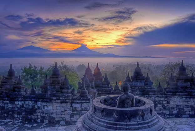
Borobudur Temple Compounds: This famous Buddhist temple, dating from the 8th and 9th centuries, is located in central Java. It was built in three tiers: a pyramidal base with five concentric square terraces, the trunk of a cone with three circular platforms and, at the top, a monumental stupa. The walls and balustrades are decorated with fine low reliefs, covering a total surface area of 2,500 m2. Around the circular platforms are 72 openwork stupas, each containing a statue of the Buddha. The monument was restored with UNESCO's help in the 1970s. Borobudur is one of the greatest Buddhist monuments in the world. Founded by a king of the Saliendra dynasty, it was built to honour the glory of both the Buddha and its founder, a true king Bodhisattva. The name Borobudur is believed to have been derived from the Sanskrit words vihara Buddha uhr, meaning the Buddhist monastery on the hill. Borobudur temple is located in Muntilan, Magelang, and is about 42 km from Yogyakarta city.

Borobudur Temple Compounds Indonesia
Continent: Asia
Country: Indonesia
Category: Cultural
Criterion: (I) (II) (VI)
Date of Inscription: 1991

Divine monuments

This colossal temple was built between AD 750 and 842: 300 years before Cambodia's Angkor Wat, 400 years before work had begun on the great European cathedrals. Little is known about its early history except that a huge army of workers worked in the tropical heat to shift and carve the 60,000 m3 of stone. At the beginning of the 11th century AD, because of the political situation in Central Java, divine monuments in that area, including the Borobudur Temple became completely neglected and given over to decay. The Sanctuary was exposed to volcanic eruption and other ravages of nature. The temple was not rediscovered until the 19th century. A first restoration campaign, supervised by Theodor van Erp, was undertaken shortly after the turn of the century. A second one was led more recently (1973-82).

Borobudur Temple Compounds Indonesia Heritage
Borobudur Temple Compounds Indonesia

Browse Gallery Plus UNESCO Storyline

five square terraces

A harmonious marriage of stupas, temple-mountain and the ritual diagram, this temple complex was built on several levels around a hill which forms a natural centre. The first level above the base comprises five square terraces, graduated in size and forming the base of a pyramid. Above this level are three concentric circular platforms crowned by the main stupa. Stairways provide access to this monumental stupa. The base and the balustrades enclosing the square terraces are decorated in reliefs sculpted in the stone. They illustrate the different phases of the soul's progression towards redemption and episodes from the life of Buddha. The circular terraces are decorated with no fewer than 72 openwork stupas each containing a statue of Buddha.

Slideshow for this Heritage Site


Browse All UNESCO World Heritage Sites in . The original UNESCO inscription Here!!!