Pages

Showing posts with label Vietnam. Show all posts

#852 Cu Chi tunnels, Vietnam

The Vietnam War was one of the most brutal and violent in recent memory, with many atrocities occuring and such as strong clash of ideological beliefs in a culmination of Cold War hostilities. In Vietnam, I saw many remarkable things that represented this war, from bombed out valleys, the infamous China Beach near Da Nang, the former DMZ, and the headquarter cities of Saigon and Hanoi. 
However one of the most interesting features was the Cu Chi tunnels, a collection of the tunnels for tourists to see and get an idea of what covered vast amounts of territory and contributed enormously to the guerilla warfare -- in particular it was the base of the Viet cong during the Tet Offensive. Used for communication, supply, hospitals, storage, homes and means of movement, they were a very developed system. Despite being important to their resistance against the Americans, life in the tunnels was not particularly pleasant, as life underground with a plethora of tropical pests in abundance, and the other major killer: malaria.

The tunnels have been considerably widened and enlarged to allow for tourists, and the original trap door entrances camouflaged in the jungle floor were designed for the small Vietnamese bodies. Booby traps and other dangers were incorporated into the system including bambo spikes, cages, holes, etc. They really were an amazing piece of engineering and certainly an aid in overwhelming the Americas t

P.S. This is also one of the only posts on my blog where I am actually in the photos, which gives you a very accurate indication of how old the photos are!

Phong Nha-Ke Bang National Park Vietnam

The karst formation of Phong Nha-Ke Bang National Park has evolved since the Palaeozoic (some 400 million years ago) and so is the oldest major karst area in Asia. Subject to massive tectonic changes, the park's karst landscape is extremely complex with many geomorphic features of considerable significance. The vast area, extending to the border of the Lao People's Democratic Republic, contains spectacular formations including 65 km of caves and underground rivers. Phong Nha - Ke Bang National Park is located in the middle of the Annamite Mountain Range in Quang Binh province, Vietnam and shares its boundary with the Hin Namno Nature Reserve in the Lao PDR to the west. The property comprises an area of 85,754 ha and contains terrestrial and aquatic habitats, primary and secondary forest, sites of natural regeneration, tropical dense forests and savanna and is rich in large, often spectacular and scientifically significant caves.

Phong Nha-Ke Bang National Park
Continent: Asia
Country: Vietnam
Category: Natural
Criterion: (III)
Date of Inscription: 2003

Outstanding limestone karst ecosystems

The property contains and protects over 104 km of caves and underground rivers making it one of the most outstanding limestone karst ecosystems in the world. The karst formation has evolved since the Palaeozoic period (some 400 million years ago) and as such is the oldest major karst area in Asia. Subject to massive tectonic changes, the karst landscape is extremely complex, comprising a series of rock types that are interbedded in complex ways and with many geomorphic features. The karst landscape is not only complex but also ancient, with high geodiversity and geomorphic features of considerable significance.

The karst formation process has led to the creation of not only underground rivers but also a variety of cave types including; dry caves, terraced caves, suspended caves, dendritic caves and intersecting caves. With a length of over 44.5 km the Phong Nha cave is the most famous of the system with tour boats able to penetrate inside to a distance of 1,500 m.

Phong Nha-Ke Bang National Park Vietnam

Browse Gallery Plus UNESCO Storyline

A large number of faunal and floral species occur within the property with over 568 vertebrate species recorded comprising 113 mammals, 81 reptiles and amphibians, 302 birds and 72 fish. This impressive level of biodiversity and species richness includes a number of endemic species as well as threatened species including tiger, Asiatic black bear, Asian elephant, giant muntjac, Asian wild dog, gaus and the recently discovered sao la.

Slideshow for this Heritage Site


Browse All UNESCO World Heritage Sites in . The original UNESCO inscription Here!!!

My Son Sanctuary Vietnam

My Son, the name in Vietnamese means "Beautiful Mountain" was sacred to the Dua clan, who worshipped the mythical king Srisanabhadresvara and governed Amaravati, the northern part of the kingdom. The Champa Kingdom began in AD 192 when the people of the Tuong Lam area rose up against their Chinese overlords and founded an independent state in the narrow strip of land along the coast of central Vietnam. This state is known from sporadic Chinese records, in which it appeared successively as Lam Ap, Hoan Vuong, and then Chiem Thanh, a transcription of Champapura, meaning "the city of the Cham people." The Cham economy was based on farming (wet-rice agriculture), fishing, and seaborne trade.

My Son Sanctuary Vietnam
Continent: Asia
Country: Vietnam
Category: Cultural
Criterion: (II)(III)
Date of Inscription: 1999

Champa Kingdom

The Cham came under the influence of the Hindu religion of the Vietnamn sub-continent early in their development, though the exact date is not known. Many temples were built to the Hindu divinities, such as Krishna and Vishnu, but above all Shiva. Mahayana Buddhism must have penetrated the Cham culture later, probably in the 4th century, and became strongly established in the north of the Champa Kingdom, but Shiva Hinduism remained the state religion. There were two sacred cities in the Champa Kingdom, each belonging to a large clan.

My Son, the name in Vietnamese means "Beautiful Mountain" was sacred to the Dua clan, who worshipped the mythical king Srisanabhadresvara and governed Amaravati, the northern part of the kingdom; it was also the capital of the whole Champa Kingdom. Whilst the religious significance of My Son was important, its location, in a small valley surrounded by high mountains gave it strategic significance as an easily defensible stronghold.

My Son Sanctuary

Browse Gallery Plus UNESCO Storyline

Successive kings in the 6th to 8th centuries favoured My Son and endowed it with fine temples. Between 749 and 875 the Cau clan were in power, and for a time the capital was moved to Vivapura in the south of the territory. Nevertheless, My Son retained its religious importance, and resumed its paramountcy in the early 9th century during the reign of Naravarman I, who won many battles against the Chinese and Khmer armies.

From the beginning of the 10th century the influence of Buddhism began to wane, to the advantage of My Son, where Hinduism had always been strong. By the reign of Giaya Simhavaram in the later 10th century it had achieved parity with Buddhism in the Cham Kingdom. It was at this time that most of the finest surviving architectural monuments were built there.

Slideshow for this Heritage Site


Most of the 11th century was a period of continuous warfare and My Son, along with other sacred sites in the Champa Kingdom, suffered grievously. It was Harivarman IV who brought peace to the kingdom. He had moved his capital to Do Ban towards the end of the century but he undertook the restoration of My Son. Warfare broke out again in the 12th century, when Jaya Indravarman IV attacked the Khmer Empire and sacked its capital. This resulted in an immediate reprisal, and the Champa Kingdom was occupied by the Khmers from 1190 to 1220.

From the 13th century the Champa Kingdom slowly declined and was absorbed by the growing power of Vietnam. It ceased to exist as an entity in the later 15th century, when worship ceased at My Son.

Browse All UNESCO World Heritage Sites in . The original UNESCO inscription Here!!!

Hoi An Ancient Town Vietnam

Hoi an Ancient Town is an exceptionally well-preserved example of a South-East Asian trading port dating from the 15th to the 19th century. Its buildings and its street plan reflect the influences, both indigenous and foreign, that have combined to produce this unique heritage site. The town is a special example of a traditional trading port in South-East Asia which has been completely and assiduously preserved: it is the only town in Viet Nam that has survived intact in this way. Most of the buildings are in the traditional architectural style of the 19th and 20th centuries. They are aligned along narrow lanes of traditional type. They include many religious buildings, such as pagodas, temples, meeting houses, etc., which relate to the development of a port community. The traditional lifestyles, religion, customs and cooking have been preserved and many festivals still take place annually.

Hoi an Ancient Town
Continent: Asia
Country: Vietnam
Category: Cultural
Criterion: (II)(V)
Date of Inscription: 1999

Trading Centre of the Sa Huynh People

Archaeological finds and excavations have shown that there was a port and trading centre of the local Sa Huynh people along the Thu Bon River as early as the 2nd century BC. This continued to expand, especially during its most flourishing period from the late 16th to the early 18th centuries. It was through Hoi An that Christianity penetrated Vietnam in the 17th century.

By the end of the century, the rise of other ports on the coast of Vietnam, in particular Da Nang, and silting of its harbour, led to the final eclipse of Hoi An. As a result of this economic stagnation, it has preserved its early appearance in a remarkably intact state, the only town in the country to have done so. The ancient town is situated on the north bank of Thu Bon River. There is a street running east-west along the river's edge and three further streets parallel to the river. They are intersected at right angles by streets and alleys. Within this area there are houses (often combined with shops), religious monuments such as pagodas, temples, communal houses and family cult houses, a ferry quay and an open market.

Hoi an Ancient Town Vietnam
Hoi an Ancient Town

Browse Gallery Plus UNESCO Storyline

The architecture of Hoi An, which is almost entirely of wood, is of considerable interest. It combines traditional Vietnamese designs and techniques with those from other countries, above all China and Japan, whose citizens settled there to trade and built houses and community centres to their own designs

Slideshow for this Heritage Site


Browse All UNESCO World Heritage Sites in . The original UNESCO inscription Here!!!

World Heritage Ha Long Bay Vietnam

Ha Long Bay, situated in the Gulf of Tonkin, includes some 1600 islands and islets forming a spectacular seascape of limestone pillars. Because of their precipitous nature, most of the islands are uninhabited and relatively unaffected by human influence. The geomorphology of Ha Long Bay is known as a drowned karst landscape due to the exceptional combination of its limestone karst features which have been subject to repeated regression and transgression of the sea over geological time. The limestones of Ha Long Bay have been eroded into a mature landscape of fengcong (clusters of conical peaks) and fenglin (isolated tower features) karst features, modified by sea invasion at a later stage.

Ha Long Bay Vietnam
Continent: Asia
Country: Vietnam
Category: Natural
Criterion: (II)(IV)
Date of Inscription: 1994

Ha Long Bay Nature of the Landscape

The smaller islands are fenglin towers of 50m to 100m high with height. Many have vertical walls on all or most sides and these continue to evolve by rock falls and large slab failures. Marine invasion of Ha Long Bay has added an extra element to the normal process of lateral undercutting of the limestone towers and islands. The most conspicuous feature being the main notch cut into the entire rocky coastline. Notches are a feature of limestone cliffs worldwide, but those of Ha Long Bay are exceptionally well developed and, at many sites, extend into arches and caves. This process of undercutting and subsequent erosion maintains the steep faces of the fenglin karst towers and thereby perpetuates the spectacular nature of the landscape.

Heritage Ha Long Bay Vietnam
Ha Long Bay Vietnam

Browse Gallery Plus UNESCO Storyline

A distinctive feature of Ha Long Bay is the abundance of lakes within the larger limestone islands. Extensive limestone caves represent another important feature of Ha Long Bay, with three main types able to be identified: old phreatic caves formed below the water table of the time; old karstic foot caves formed by lateral undercutting of cliffs at base level; and marine notch caves formed at sea level where rock structures are powerfully eroded and eventually reduced to a wave cut platform.

Slideshow for this Heritage Site


In summary, Ha Long Bay possesses a tremendous diversity of caves and other landforms which derive from the unusual geomorphological process of marine invaded tower karst. These areas provide a unique and extensive reservoir of data for the future understanding of geoclimatic history and the nature of karst processes in a complex environment.

Browse All UNESCO World Heritage Sites in . The original UNESCO inscription Here!!!

Complex of Hue Monuments Vietnam

Complex of Hue Monuments represents an outstanding demonstration of the power of the vanished Vietnamese feudal empire at its apogee in the early 19th century. The complex of monuments is an outstanding example of an eastern feudal capital and of the planning and construction of a complete defended capital city in a relatively short period. The integrity of town layout and building design make it an exceptional specimen of late feudal urban planning. Hue served as the administrative centre of southern Vietnam in the 17th and 18th centuries. Gia Long, first ruler of the Nguyen dynasty, made it the national capital of united Vietnam in 1802, a position that it held until 1945.

Complex of Hue Monuments Vietnam
Continent: Asia
Country: Vietnam
Category: Cultural
Criterion: (IV)
Date of Inscription: 1993

Hue Monuments

Hue is situated in the geographical centre of the country and with easy access to the sea. The new capital was planned in accordance with ancient oriental philosophy in general and Vietnamese tradition in particular; it also respected the physical conditions of the site, especially the Perfume River and Ngu Binh Mountain (known as the Royal Screen)

The relationship between the five cardinal points (centre, west, east, north, south), five natural elements (earth, metal, wood, water, fire), and five basic colours (yellow, white, blue, black, red) underlies the conception of the city, and is reflected in the names of some important features. The Perfume River, the main axis, divides the capital in two.

Complex of Hue Monuments

Browse Gallery Plus UNESCO Storyline

Four citadels or defended enclosures made up the city: Kinh Thanh (Capital City), for official administrative buildings; Hoang Thanh (Imperial City) for royal palaces and shrines; Tu Cam Thanh (Forbidden Purple City) for the royal residences; Dai Noi (or Inner City); and Tran Binh Dai, an additional defensive work in the north-east corner of the Capital City, designed to control movement on the river. A fifth fortress, Tran Hai Thanh, was constructed a little later to protect the capital against assault from the sea.

Slideshow for this Heritage Site


Planning lasted from 1803 to 1805, and it was not until 1832 that construction was complete. The new capital was much larger than its predecessor, Dong Trang, and encompassed several villages as well. The fortress itself was modelled on the European style of Vauban, the first of its type in South-East Asia, but the complex suffered considerably as a result of military operations in 1885, 1947 and 1968.

The main enceinte, the Capital City, is square in plan, each side measuring 2,235 m. The defensive walls have six projecting bastions on each side and ten gates. The external defensive works comprise a berm, ditch, and glacis. The buildings inside the Capital City include various former ministerial buildings, the Royal College and the Hué Museum.

The Inner City is rectangular in plan and defended by brick walls, supplemented by a moat and wide berm; there is a single entrance on each of the walls. Inside it is divided by walls into a number of zones - the Great Ceremonies Zone, the Worshipping Zone, the residential zone of the King's Mother and Grandmother, the storage and workshop zone, the garden and school zone for royal princes, as well as the Forbidden Purple City. The palaces within the Inner City are similar in style and design, set on a raised podium, with wooden trusses (usually ironwood), gilded and painted pillars and rafters, brick walls, and roofs of yellow- or blue-glazed cylindrical tiles. Roof edges are straight, and the decoration, both internally and externally, is abundant. Among the most important buildings are the Palace of Supreme Harmony, the royal reception hall; the Mieu Temple, the royal place of worship; the Queen Mother's Palace; and the Pavilion of Dazzling Benevolence.

At the heart of the complex is the Forbidden Purple City, surrounded by brick walls. There is a single gate in the front wall, reserved for the use of the king, and the other walls have several entrances, each with a specific purpose. Originally there were over 40 buildings within the walls, but most are now in ruins and only their foundations survive.

Outside the Capital City there are several associated monuments of importance. These include the tombs of the Nguyen dynasty to the south of the Perfume River. Other structures along both banks of the river are buildings related to the spiritual life of the dynasty, including the Temple of Literature, the Esplanade of the Sacrifice to the Sun and Earth, the Royal Arena and the Temple of the Roaring Elephant, and the Celestial Lady Pagoda.

Browse All UNESCO World Heritage Sites in . The original UNESCO inscription Here!!!

Central Sector of the Imperial Citadel of Thang Long

The Central Sector of the Imperial Citadel of Thang Long -- Hanoi, located in the heart of the capital of Viet Nam, is the most important and best-preserved part of the ancient Imperial Citadel of Thang Long. The Thang Long Imperial Citadel was built in the 11th century by the Vietnamese Ly Dynasty, marking the independence of the Đại Việt. It was built on the remains of a Chinese fortress dating from the 7th century, on drained land reclaimed from the Red River Delta in Hanoi. It was the centre of regional political power for almost thirteen centuries without interruption.

Central Sector of the Imperial Citadel of Thang Long
Continent: Asia
Country: Vietnam
Category: Cultural
Criterion: (II)(III) (VI)
Date of Inscription: 2010

Archaeological Monuments

The buildings of the Imperial Citadel and the remains in the 18 Hoang Diêu Archaeological Site reflect a unique South-East Asian culture specific to the lower Red River Valley, at the crossroads of influences coming from China in the north and the ancient Kingdom of Champa in the south. The Imperial Citadel of Thang Long is characterized by its longevity and continuity as a seat of power, evidenced by different archaeological levels and monuments.

Imperial Citadel of Thang Long
Central Sector of the Imperial Citadel of Thang Long

Browse Gallery Plus UNESCO Storyline

The Imperial Citadel of Thang Long

The Central Sector of the Imperial Citadel of Thang Long - Hanoi bears witness to the meeting of influences coming mainly from China in the north and the Kingdom of Champa in the south. It expresses a set of intercultural exchanges which shaped a unique culture in the lower Red River Valley.

The Central Sector of the Imperial Citadel of Thang Long bears witness to the long cultural tradition of the Viêt populations established in the Delta and the lower Red River Valley. It was a continuous seat of power from the 7th century through to the present day.

The Imperial Citadel of Thang Long at Hanoi, with its political function and symbolic role, is directly associated with numerous and important cultural and historical events, and leading artistic expressions and moral, philosophical, and religious ideas. The succession of these events marks the formative and development process of an independent nation over more than a thousand years, including the colonial period and the two contemporary Wars of Independence and reunification of Viet Nam.

The continuity of its political role is demonstrated by the archaeological elements brought to light and by the later built elements of the Thang Long Citadel. In spite of absent and not always very visible evidence, the conditions of integrity in terms of the architecture, structure and landscaping of the property are acceptable. The very promising archaeological vestiges of the 18 Hoang Diêu site must be completed by a study programme on the scale of the property for confirmation of the archaeological integrity.

Slideshow for this Heritage Site


Authenticity

The degree of authenticity expressed by the architecture of Thang Long corresponds to buildings of the late 19th and the 20th centuries. Older buildings, dating back to the dynastic periods, notably the Doan Mon Gate and the Hau Lau Palace, have been restored and modified. However, these changes are related to the political history of the property. Over the long historical period of the Citadel of Thang Long, the archaeological authenticity of the property is good, even if expressed by only a small excavation area. The degree of authenticity of the architecture is variable depending on the period examined, being more satisfactory for the contemporary and colonial buildings.

Requirements of Protection

The legal protection of the property is based primarily on two laws: the Law on Cultural Heritage (2001) which ensures the protection of the various recognized moveable and immoveable components of the property, and the Law on Construction for all work and projects. In the event of discordance in the application of these two laws, for example for a proposed project in the territory of the property nominated for inscription, the Law on Heritage Management takes precedent. The legal protection in place is appropriate for the property, but it must be completed and a wider buffer zone should be envisaged.

The management authority is well-defined and already functional: in 2006, the People's Committee of Hanoi entrusted the Co Loa and Thang Long Vestiges Preservation Centre, also called Thang Long Centre, with the responsibility for the management of the property. The general guidelines of the Management Plan are satisfactory, but this Plan must be enacted, and the archaeological studies component should be strengthened and expanded. Furthermore, the capacity building for the personnel involved in the conservation of the property should be enhanced.

Browse All UNESCO World Heritage Sites in . The original UNESCO inscription Here!!!

Citadel of the Ho Dynasty Vietnam

The Citadel of Ho Dynasty built in 1397, composed of the Inner Citadel, La Thanh Outer Wall and the Nam Giao Altar covers 155.5 ha, surrounded by a buffer zone of 5078.5 ha. It is located in accordance with geomantic principles in a landscape of great scenic beauty between the Ma and Buoi rivers in Vinh Loc district, Thanh Hoa province of Viet Nam. The Inner Citadel constructed of large limestone blocks represents a new development of architectural technology and adaptation of geomantic city planning in an East Asian and South-east Asian context. It demonstrates the use of architectural elements in terms of space management and decoration designed for a centralized imperial city in order to show a concept of royal power, based on the adoption of the Confucian philosophy within a predominantly Buddhist culture.

Citadel of the Ho Dynasty Vietnam
Continent: Asia
Country: Vietnam
Category: Cultural
Criterion: (II)(IV)
Date of Inscription: 2011

Buddhist Values

The capital of Viet Nam from 1398 to 1407 and also the political, economic and cultural centre of North Central Viet Nam from the 16th to the 18th century, it bears exceptional testimony to a critical period in Vietnamese and South-east Asian history when traditional kingship and Buddhist values were giving way to new trends in technology, commerce and centralized administration.

Citadel of the Ho Dynasty

Browse Gallery Plus UNESCO Storyline

The Ho Citadel is an Outstanding Example

The property exhibits Chinese Confucianism influence on a symbol of regal centralized power in the late 14th – early 15th century. It represents new developments in architectural style with respect to technology and, in adapting pre-existing geomantic city planning principles in an East Asian and South-east Asian context, makes full use of the natural surroundings and incorporated distinctly Vietnamese and East and Southeast Asian elements in its monuments and landscape.

The Ho Citadel is an outstanding example of an architectural ensemble in a landscape setting which illustrates a flowering of pragmatic Neo-Confucianism in late 14th century Viet Nam, at a time when it was spreading throughout East Asia to become a major philosophical influence on government in the region. The use of large blocks of stone testifies to the organizational power of the Neo-Confucian state, and the shift in the main axis distinguishes the Citadel layout from the Chinese norm.

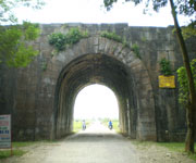
The integrity of the property is guaranteed by the areas of the three major components which represent the characteristics of the Ho Dynasty: the Inner Citadel, the Nam Giao altar and part of La Thanh Outer Wall. These elements reflect the presence of a citadel that has remained almost intact, with massive stone walls within a landscape setting that is easily recognizable. Excavations have also demonstrated a rich source of archaeological evidence preserved underground below the present rice and other crops within the boundaries of the three components.

Slideshow for this Heritage Site


The buffer zone includes all cultural elements that were part of a large imperial city during the late 14th – early 15th century, including religious monuments, traditional villages, common houses, ancient roads, markets, landing places and scenic beauty spots, which are a direct tangible expression of the cultural values of the property.

The conditions of authenticity in terms of the geo-cultural location and landscape setting of the property are almost unchanged; the layout and architectural design and materials of the Inner Citadel's walls, four gates, sections of moat, and section of La Thanh Outer Wall and archaeological remains of Nam Giao Altar are well preserved. The archaeological excavations in the property reveal well-preserved structures contemporaneous with the Ho Dynasty.

The Inner Citadel and Nam Giao Altar were designated in 1962 as national heritage by Decision of the Ministry of Culture of the Democratic Republic of Vietnam and are protected under the Law on Cultural Heritage of 29/06/2001. The nominated section of La Thanh Outer Wall is in the process of being similarly protected.

The buffer zone is protected by the Law on Environmental Protection of the Socialist Republic of Vietnam, number 52/2005/QH11, Chapter 4, Article 31 of 2005. The property is directly managed by the People's Committees of the relevant communes for the particular component sites, under the Management Board of the Citadel of the Ho Dynasty established by Decision 2264/QD-UBND (30 July 2007).

A comprehensive five–year Management Plan for the property was submitted in November 2010. The control of urban development near the Inner Citadel, in Vinh Loc town particularly along the axis between the Inner Citadel and Mount Don Son, and in the buffer zone generally should receive specific attention so as to protect all view lines along the axes between topographical features, and views within the area enclosed by the line of the outer wall and the Ma and Buoi rivers.

Special attention is needed for the development of a risk-preparedness and management strategy and a strategy for involving local people in the protection and management of the property. The local authority and people are working closely for the preservation and protection of the property through a training and public-awareness raising programme.

Browse All UNESCO World Heritage Sites in . The original UNESCO inscription Here!!!

#958 Ha Long Bay, Vietnam

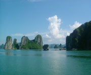
An other-worldly place with plugs of limestone rock shooting up from a peaceful, picturesque bay as if someone decided to create a maze of rock, but then it eroded into the sea, Ha Long Bay literally means 'Dragon descending', and it's the kind of place where the mythology that named it seems like it could happen there.

With thousands of islands ranging in size, many with caves and minimal vegetation, the bay stretches several kilometers and from the place where you set sail in order to visit the many islands, you can't see the open sea. The distinctive twin sail boats with trapezoidal yellow sails are not a fast journey and feel timeless, despite the modern amenities.

Pictures: Film, 1998
Source: http://en.wikipedia.org/wiki/Ha_Long_Bay


#963 Mekong Delta, Vietnam

The Mekong River is one of the most impressive in South East Asia, flowing through several countries: China to Myanmar, Laos to Thailand, then Cambodia before ending its journey in Vietnam. Its name is of Lao and Thai origin and has been a trade route for centuries, although its flows change greatly from season to season. You can see the fresh water pink dolphin (although quite rare now), a softshell turtle, crocodiles and wave to the many different peoples living along the banks, but what I loved the most were the number of people who lived on the river itself. The trade was as it has been for centuries and the superstitions continued, such as putting eyes on the boat to prevent bad spirits.

Note: These pictures are so old they were taken with film: Christmas 1998. 
Source: http://en.wikipedia.org/wiki/Mekong

Son doong Goa - Goa The Whistle

Son doong Goa is located in National Park Phong Nha-Ke Bang, Bo Trach District, Quang Binh Province. Son doong Goa has a length of about 5 km, height 200 m, and width of 150 meters which was named the world's largest cave beat Deer Cave in Malaysia which has only 2km size, height of 100 meters and 90 meters wide.

Besides having a very large size, it turns out Goa also has another uniqueness of this cave could spend all day whistling sound no matter how it's night or day. The locals were afraid to approach the cave, let alone get in it. Because of the cave appears strange noises, like whistles which makes hair-raising goose bumps. Belief in the supernatural can sometimes be the great discovery that has been a barrier in sight.


Until the end of last year, a group of British scientists reveal the "hidden treasure" Vientam. The researchers came to Son doong Cave for observation. How surprised they were, it turns out that the vast cave. This cave was five times larger than the largest cave in Vietnam, Phong Nha, even after the measure, far greater extent than the world's largest cave, Deer in Malaysia.

But a team of British researchers from the British Cave Research Association, the work reveals the strange noises that had been feared by residents. According to them a strange whistling wind was coming from a river underground water is very heavy so that the echo sounds strange.

Actually, the British scientist who first discovered this was not the giant cave. Are locals ie, HO-Khanh who discovered it in 1991. He had been told about the discovery, but no one dared to come there because of odd whistles that come from within.